Camp Osito Road – 2N17

Camp Osito Road is a back country 4×4 trail which connects Knickerbocker Road to Skyline Drive in Big Bear, California. The seldom travelled road is an access route to a local Girl Scout Camp.

Camp Osito Road - 2N17 - Trailhead from Knickerbocker Road near Big Bear, California
Camp Osito Road – 2N17 – Trailhead from Knickerbocker Road near Big Bear, California

Route 2N17 branches from the Knickerbocker trail about two miles from either end and wanders towards the west by Camp Osito. From there, the route continues through the heart of the San Bernardino Mountains until it intersects with Skyline Drive. This is at best an intermediate trail and offers views of Big Bear Lake and the surrounding forests and manzanita groves.

Big Bear Mountains, nestled in the heart of Southern California, offer a breathtaking escape into nature’s splendor. With a majestic backdrop of towering pines and rugged terrain, this mountainous haven beckons outdoor enthusiasts and adventure seekers alike. The towering peaks, including San Gorgonio Mountain, provide year-round recreational opportunities, from exhilarating ski slopes in the winter to invigorating hiking trails during warmer months.

Due to the proximity to Big Bear, it is quite common for this route to be used by hikers, bickers, quad riders and 4x4s alike, so keep an eye out for traffic.

Trail Summary

NameCamp Osito Road
LocationBig Bear, San Bernardino, California
Latitude, Longitude34.2243, -116.9378
Elevation7,500 feet
Distance1.8 Miles
Elevation Gain352 feet

Trail Map

Camp Osito Road is part of the South Shore Trail Network located in the San Bernardino Mountains, near Big Bear, California.
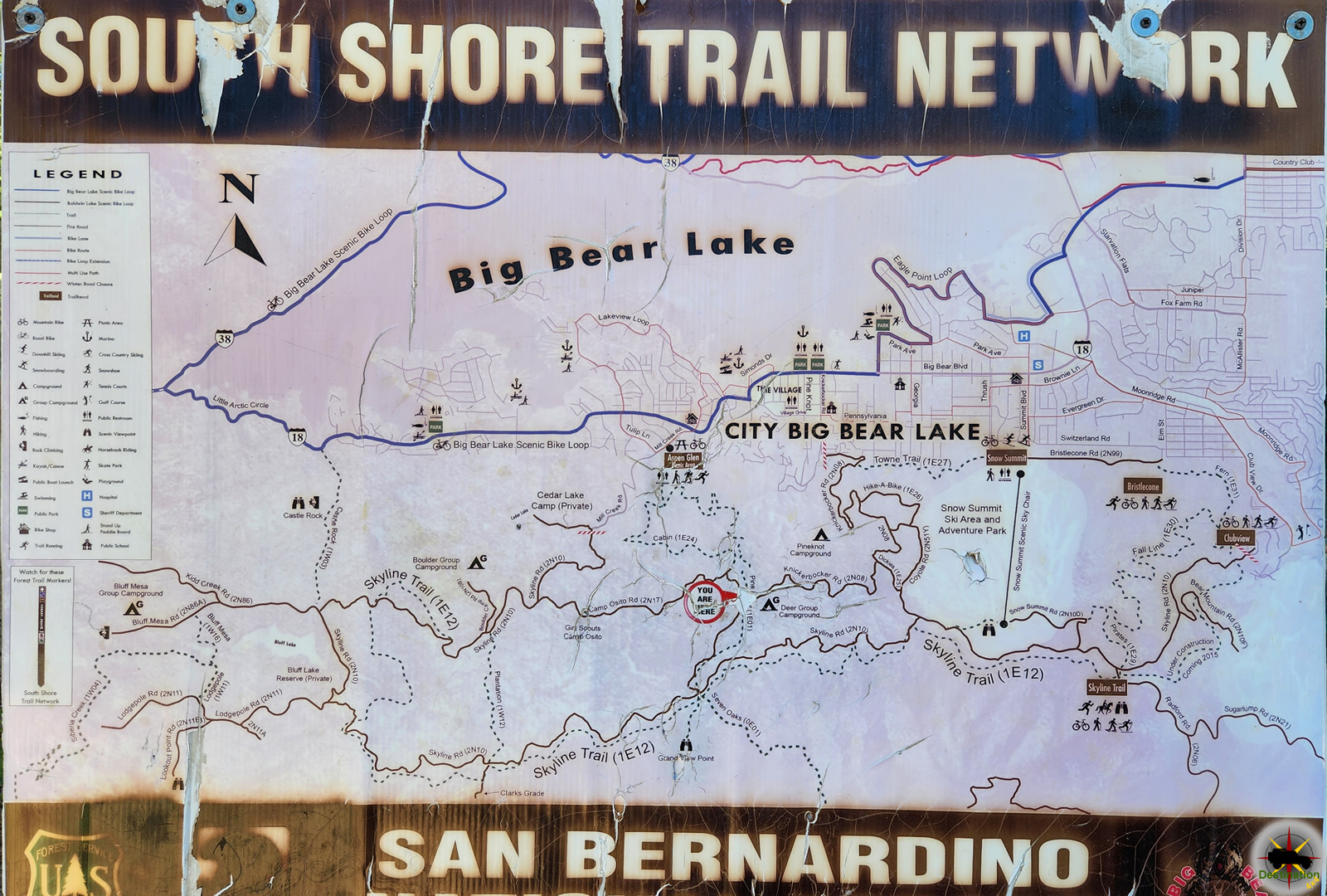


Camp Osito Road - 2N17 - Trailhead from Knickerbocker Road near Big Bear, California

Camp Osito Road – 2N17

Camp Osito Road is a back country 4x4 trail which connects Knickerbocker Road to Skyline Drive in Big Bear, California. The seldom travelled road is…
Clarks Grade 1N54 Trail Head dropping down into Barton Flats from Skyline Drive.

Clarks Grade 1N54

Clarks Grade 1N54 Trail Head dropping down into Barton Flats from Skyline Drive. Clarks Grade 1N54 is a steep and scenic descent from the top…
Big Bear Lake viewed from Knickerbocker Road.

Knickerbocker Road – 2N08

Knickerbocker Road - 2N08 is a steep and beautiful drive from near the town of Big Bear, California to Skyline Drive. The route is a…
Skyline Drive 2N10 offers higher elevation views of Big Bear, California

Skyline Drive 2N10

Skyline Drive 2N10 offers higher elevation views of Big Bear, California Skyline Drive 2N10 is the unofficial name for USFS Road 2N10 that begins just…

Knickerbocker Road – 2N08

Knickerbocker Road – 2N08 is a steep and beautiful drive from near the town of Big Bear, California to Skyline Drive. The route is a popular destination and common for hikers, bikes and vehicles alike. The route winds up the mountain from the village in Big Bear up to the top of the mountain offering some spectacular vistas and the valley below.

Big Bear Lake viewed from Knickerbocker Road.

Knickerbocker Road – 2N08 is accessed from Highway 18 in Big Bear, about two blocks east of the village. The trail head is located 3/4 of a mile from the highway off of Knickerbocker Road. The trail begins with a tight left turn and steeply gains alititude. from the valley floor on its journey up to Skyline Drive.

Intersection with 2n17 about two miles from either end of Knickerbocker Road.

Along the route, you journey deep into a lush pine forest with a few seasonal streams to nourish the lush green plant life. Manzanita Bushes fill the landscape, along with a variety of seasonal wild flowers as you continue to climb to the ridge of the mountain. Don’t forget to admire the views of Big Bear lake as you make the journey.

Once the trail terminates at the Grand View Vista at Skyline drive, there is a very small parking area to relax, picnic and enjoy the alpine view of Barton Flats and valley below. From here, you can return as you came, or pick any of several trails from the South Shore Trail Network including Skyline Drive,

Knickerbocker Road Trail Summary

NameKnickerbocker Road – 2N08
LocationBig Bear, San Bernardino County, California
Latitude, Longitude34.2162, -116.9192
Length4 Miles
Elevation Gain890 feet

Trail Map

Knickenbocker Road is part of the South Shore Trail Network.


Camp Osito Road - 2N17 - Trailhead from Knickerbocker Road near Big Bear, California

Camp Osito Road – 2N17

Camp Osito Road is a back country 4x4 trail which connects Knickerbocker Road to Skyline Drive in Big Bear, California. The seldom travelled road is…
Clarks Grade 1N54 Trail Head dropping down into Barton Flats from Skyline Drive.

Clarks Grade 1N54

Clarks Grade 1N54 Trail Head dropping down into Barton Flats from Skyline Drive. Clarks Grade 1N54 is a steep and scenic descent from the top…
Big Bear Lake viewed from Knickerbocker Road.

Knickerbocker Road – 2N08

Knickerbocker Road - 2N08 is a steep and beautiful drive from near the town of Big Bear, California to Skyline Drive. The route is a…
Skyline Drive 2N10 offers higher elevation views of Big Bear, California

Skyline Drive 2N10

Skyline Drive 2N10 offers higher elevation views of Big Bear, California Skyline Drive 2N10 is the unofficial name for USFS Road 2N10 that begins just…

Alamo Crossing Mohave County Ghost Town

Alamo Crossing is a submerged ghost town hidden beneath the waters of Alamo Lake, Mohave County, Arizona.

Alamo Crossing, Mohave County Arizona

The town is founded by Tom Rogers about 1899. The little hamlet served as a small mining community to transient prospectors with most of the population camping out. During its heyday, the town only consisted of a five-stamp mill, a few stores and a post office. The town’s population is never known to be significant.

In 1968, an earth filled damn is constructed along the Bill Williams River by the Army Corp of Engineers for flood control. The 283 foot tall damn caused the formation of Lake Alamo, which is about 80 feet deep. The remains of Alamo Crossing still lie in the waters of the lake. Scuba gear is required to explore the remains. The town site was believed to be one of the best preserved ghost towns in the county, prior to flooding.

In 2020, the area surrounding Alamo is revived for mining again, this time for placer gold prospecting.

Trail Map

Town Summary

NameAlamo Crossing
Also Known AsAlimo,
LocationAbout 60 miles northwest of Wickenberg on Bill Williams River, Mohave County, Arizona
Latitude, Longitude34.2605, -113.5827
Elevation1,237 ft (377 m)
GNIS25299
Post officeNovember 13, 1889 – December 15, 1900
March 30, 1911 – 1918 Alamo

References

Warren Baxter Earp

Warren Baxter Earp ( March 9, 1855 – July 6, 1900 ), the youngest of the Earp brothers, was born into a family that would become synonymous with the Wild West and the lawlessness of frontier America. Though not as famous as his older brothers Wyatt, Virgil, and Morgan, Warren’s life was marked by the same tumultuous spirit and sense of loyalty that defined the Earp family.

Warren Baster Earp ( March 9, 1855 - July 6, 1900 )
Warren Baster Earp ( March 9, 1855 – July 6, 1900 )

Early Life

Warren Baxter Earp was born on March 9, 1855, in Pella, Iowa, to Nicholas Porter Earp and Virginia Ann Cooksey. As the youngest of the Earp brothers, Warren grew up in a household that was constantly on the move, eventually settling in Colton, California. Unlike his older brothers, Warren did not participate in the Civil War, as he was too young. He was, however, deeply influenced by his older siblings, particularly Wyatt and Virgil, who served as lawmen in the rough-and-tumble towns of the American West.

Tombstone and the Earp Vendetta Ride

Warren Earp first made his way to Tombstone, Arizona, in the early 1880s, joining his brothers in the bustling mining town. Although he was not directly involved in the famous Gunfight at the O.K. Corral on October 26, 1881, Warren’s presence in Tombstone placed him at the heart of the events that followed.

After the assassination of his brother Morgan in March 1882, Warren became an active participant in the Earp Vendetta Ride, a series of revenge killings led by Wyatt Earp. The Vendetta Ride was a direct response to the murder of Morgan and the perceived lack of justice from local authorities. During this period, Warren showed his loyalty to his family, joining his brothers in hunting down those they believed were responsible for Morgan’s death.

Later Life

After the events in Tombstone, Warren Earp led a relatively unsettled life, drifting across the West and working various jobs, including as a cowboy, stagecoach driver, and occasional lawman. Unlike his brothers, who eventually found some measure of stability, Warren never fully escaped the shadow of his family’s tumultuous past. His fiery temper and propensity for getting into conflicts often put him in dangerous situations.

By the late 1890s, Warren Earp had made his way to Willcox, Arizona, a small but lively cattle town that served as a hub for ranchers and cowboys in the region. Willcox, like many frontier towns, was a place where disputes were often settled with fists or firearms rather than words, and Warren, with his reputation and temperament, fit right into this rough environment.

The Fatal Encounter

On the evening of July 6, 1900, Warren Earp found himself at the Headquarter Saloon in Willcox. He had been drinking and, according to various accounts, was in a combative mood. Warren had a longstanding grudge against a local ranch hand named John Boyett, and that night, the simmering tensions between the two men came to a head.

Details of what transpired in the saloon are somewhat unclear, as different witnesses provided varying accounts of the events. However, it is generally agreed that Warren, who was known for his temper, began provoking Boyett, possibly over some perceived slight or lingering resentment. The confrontation escalated quickly, and Warren, who was unarmed at the time, reportedly taunted Boyett, daring him to draw his weapon.

Feeling threatened and perhaps fearing for his own life, John Boyett drew his revolver and shot Warren Earp, striking him in the chest. Warren collapsed to the floor and died shortly thereafter, his life ending in a manner not unlike the violent encounters that had defined much of his family’s history.

Legacy

Warren Baxter Earp was buried in the Willcox Cemetery, and while his grave is not as visited as those of his more famous brothers, it remains a part of the larger Earp legend. Warren’s life, though cut short, exemplifies the rough and often violent existence of men living on the frontier. His story is a reminder that the Earp family legend is not just one of heroism and law enforcement but also of the complexities and contradictions that defined the American West.

Earp Family Members

James Cooksey Earp ( June 28, 1841 - January 25, 1926 )

James Cooksey Earp

James Cooksey Earp ( June 28, 1841 - January 25, 1926 ) James Cooksey Earp ( June 28, 1841 - January 25, 1926 ) was…
Morgan Earp historical photo, 1881. Probably taken by C.S. Fly.

Morgan Seth Earp

Morgan Seth Earp, born on April 24, 1851, in Pella, Iowa, was a notable figure of the American Old West, primarily recognized for his association…
Virgil Earp 1843 -1905

Virgil Walter Earp

Virgil Walter Earp ( July 18, 1843 – October 19, 1905) was born in Lincoln County, Kentucky, was a prominent lawman and frontier figure known for his…
Warren Baster Earp ( March 9, 1855 - July 6, 1900 )

Warren Baxter Earp

Warren Baxter Earp ( March 9, 1855 - July 6, 1900 ), the youngest of the Earp brothers, was born into a family that would…
Wyatt Berry Stapp Earp - Aged 39

Wyatt Berry Stapp Earp

Wyatt Berry Stapp Earp (March 19, 1848 – January 13, 1929) was an American lawman and gambler who became a legendary figure of the Old…

Wilbur’s Grave

Charles Wilbur’s Grave is a point of interest located in Holcomb Valley near the Holcomb Valley Campground, San Bernardino, California.

Charles Wilbur's Grave located in Holcomb Valley, San Bernardino, California
Charles Wilbur’s Grave located in Holcomb Valley, San Bernardino, California

In 1859, prospecting in Holcomb valley lead to the discovery of gold and one of the largest deposits in southern California. Charles Wilbur was a placer gold miner in Holcomb Valley in the who moved into the area in the 1880’s. Trusted and liked by his fellow miners, he was elected to establish boundaries so that the gold claims could be accurately established in the valley. Later, Wilbur was elected to the first tax assessor in San Bernardino County.

Prior to his death, he let it be known that he wanted to be buried next to his favorite location in the San Bernardino Mountains. Located across the road from Wilbur’s pond is the marker for Wilbur’s grave. Wilburs pond is a settling pond for gold miners and may have been the site of several placer claims. It should be noted that he is buried in the area and not at the specific location of the marker. The location is a well marked popular destination and local landmark to back-road explorers, hikers, mountain bikers, trail runners and geocachers alike.

Wilbur’s Grave Summary

NameWilbur’s Grave
LocationHolcomb Valley, San Bernardino, California
Latitude, Longitude34.3062, -116.9003

Point of Interest Map

Wilbur’s grave is located along the 3N07 just off the Holcomb Valley Road, 3N16. The Grave is located near Wilburs pond, which is seasonal.

References