Chloride City California – Inyo County Ghost Town

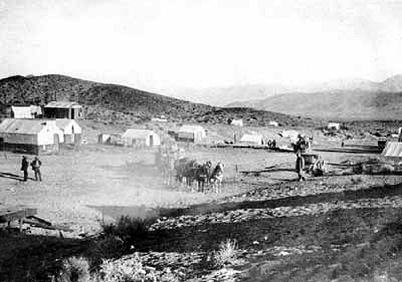
Chloride City California is located within Death Valley National Park and Inyo County, California. The town arose out of silver discoveries in nearby Chloride Cliff in 1873 and is one of the earliest of the Death Valley mines.

The first road through Death Valley was constructed from Chloride City, California to San Bernardino, California which was the nearest town 180 miles away. In the 1870’s ore was shipped out using trains of pack mules which would return carrying food and supplies to the camp. The mines of this small community struggled on for a few years, but by 1880 no mines were producing and everybody had moved on.

Crowells Mill under construction in Chloride City, CA about 1915

The nearby Bullfrog, Nevada, gold discovery excitement of 1904 brought in new capital. The Chloride Cliff Mine was bought by investors in nearby Rhyolite and re-opened in 1908. Sufficient ore was produced in subsequent years to warrant the construction of a cyanide mill in 1916. By 1918 the camp was deserted again.

The ghost town contains numerous adits, dumps and the grave of James McKay, of whom nothing is known. The town also holds the remains of three stamp mills.

Chloride City Trail Map

Greenwater California – Inyo County Ghost Town

In 1904, a copper strike near Greenwater Spring and ensuing rush to profit caused the formation of Greenwater in Inyo County, California. Originally known by two other names, Kunze and Ramsey, the merger of these two small towns led to the formation of Greenwater in 1906.

Greenwater Mining District, CA 1906

The discovery of gold in Rhyolite triggered a flood of prospecting and brought civilization closer to this remote area of Death Valley. This waver of prospecting found many small mining camps spring into the area and Greenwater was just a town.

Greenwater California 1907

Greenwater was a short lived venture. The tent city grew to a population of of about 1,000 people. Although the town contained about a dozen saloons, water needed to be transport in and cost $15 / barrel. Despite newspaper promotions at the time and financial backing of investors, the town began to falter in 1907 due to lack of profits.

Greenwater California

Today, very little remains can be found in Greenwater California. Like many mining towns of its day, the population lived in hastily assembled canvas sided tents. It is easy to imaging, the town literally packing up their tents and moving on the the next great boom.

Greenwater Town Summary

NameGreenwater
Also Known Kunze, Ramsey
LocationInyo County, Death Valley, California
Latitude, Longitude36.179444, -116.616389
Elevation4,280 feet
NewspaperGreenwater Times ( 1906-1908 )

Greenwater Map

References

Panamint City California – Inyo County Ghost Town

Panamint City California - 1875
Panamint City California – 1875

Panamint City California is a ghost town and silver mine site located in Inyo County. The town site was built in Surprise canyon in the Panamint Mountain Range which is now located within Death Valley National Monument. Currently, the town is only accessible to hikers. Previously, it was possible to drive into the ghost town, however a series of flash floods washed the roads completely out.

Interest is the area was initidated in 1872, when silver was discovered by three bandits who were hiding out in Surprise Canyon. These bandits were William L. Kennedy, Robert L Stewart and Richard C. Jacobs where in Surprise Canyon doing some prospecting and looking for the Lost Gunsite Mine. The men were wanted for robing the Wells Fargo Stages. The men entered into an arrangement, and sold their claim to Nevada Senator John P Jones. Silver samples assayed as high as $3,000 per ton, with the probable average value of metal-bearing ore being at least $125 a ton. The Honorable Mr. Jones arranged for amnesty for the bandits and they agreed repay the stolen $12,000 from their profits.

Senator John Percival Jones

Nevada Senator John P Jones and fellow Nevada Senator William M Stewart created the Panamint Mining Company and bought up the larger mines in the canyon. The location started to boom with the involvement of the two senators.

William M. Stewart. Photo by Matthew Brady

Panamint City was founded in 1873 – 1974 and soon the town contained all of the services and stores required to support a town of 2000 people. Mines, Saloons, stores, post office, cemetery and a red light district were all built in the upper end of the canyon and arranged along a single road about one mile long. In general, most of these mining booms towns earned a reputation for lawlessness and Panamint City was no different.

Due to the towns reputation, Wells Fargo refused to open an office in Panamint City. To transport the silver from the town, the bullion was caste into 450 round balls, which were then transported in wagon to Los Angeles, CA

Panamint City Stamp Mill

Flash floods are a constant danger, and on July 24, 1786, Panamint City experience just such a flood. This flood washed out most of the young town. Inyo county maintained a road into Surprise Canyon until 1983 when a flash flood again scoured the canyon. Currently, there is no vehicle access. Much of the Panamint City Stamp Mill is gone, however the tall brick smoke stake still stands as a sentinel in time to mark the location of the town.

Panamint Town Summary

NamePanamint
LocationInyo County
Latitude, Longitude36.1182827, -117.0953327
GNIS1661185
Elevation6,300 Feet
NewspaperPanamint News ( 1874-1875 )

Panamint Map

References

Nelson Nevada and Eldorado Canyon – Clark County Ghost Town

Rock spires carved by erosion located in Eldorado Canyon, Nelson, Nevada.

The ghost town of Nelson, Nevada, which is located in Eldorado Canyon along Lake Mojave, is a quaint destination which offers the visitor a brief glimpse into the past.

History

The Southwest Mining Company Quartz mill located just off the Colorado River.

El Dorado Canyon has a long and storied mining history which includes 150 years of mining activities by Native Americans, Spanish Explorers and Mormons prior to 1861. In 1863, miners from nearby Potosi flooded the area and established four town sites in the narrow canyon, the establishment of which caused some excitement on the western coast.

Many structures are still standing, Nelson, Nevada.

In 1864, near the mouth of Eldorado canyon a ten-stamp stamp mile is built. This despite a six month lead time for supplied to arrive in the remote location. At the time, Eldorado canyon was part of the Arizona territory and the Eldorado mill was the first in the Arizona territory.

The steamboat Mohave departing the landing in El Dorado Canyon.

As the town grew, in 1865 the town added a post office. However the area was a rough camp with the nearest law about 300 miles away. Vigilantes dispensed justice to those who crossed the line.

Mill in Eldorado Canyon, circa 1890

Founded in 1905 Nelson, Nevada is located some seven miles west at the head of Eldorado Canyon. The town of Nelson slumped for two decades beginning in 1909, but the 1930’s found a resurgence in gold production. By 1941, the three cyanide mills processed 220 tons of ore daily. The population reached 600 persons, however increased costs caused the gold production to slow and eventually cease. The Techatticip mine produced over half of the total gold produced in the area. The gold produced by the region has an estimated valued at $10,000,000.00.

In 1951, Davis Damn is completed. The original town site in Eldorado canyon was buried and drowned by the rising waters of Lake Mojave.

A visitors center and store are open to those who travel here.  Nelson, Nevada
A visitors center and store are open to those who travel here. Nelson, Nevada

Today

Today, the town of Nelson hosts some 37 people in the 2010 census. The older section of town hosts many old buildings, ruins, cars, mining equipment and all in all is an eclectic collection of mining and western history. The current occupants have a wonderful collection of old mining gear and western history, mixed with an eclectic collection of art.

Nelson, Nevada

The town was recently used as a movie set, and the a tour of the town is available to those interested.

Nelson, Nevada is a quiet destination worthy of a few hours if you are in the area.

Nelson and El Dorado trail map

Goffs California – San Bernardino County Ghost Town

Originally known as Blake, Goffs, California is a small unincorporated community located off of Route 66 in the Mojave desert near the Piute Mountains.  Originally named for Isaac Blake, builder of the Nevada Southern Railway, the town was named Goffs in 1902, when it served as a railway stop, and housing for the Santa Fe Railroad.

Goffs, CA
Goffs California

In 1914, Goffs built a schoolhouse which served 1000 square miles of the surrounding desert.  The students were primarily children of railroad employees, miners and Mexican immigrant families.  The school continued to function as a educational facility until it’s closure in 1937 when the Goffs School District was merged with  the nearby Needles school district.  During World War II, the “Mission Revival” building served as a canteen for the Desert Training Center, which trained US servicemen for the hardships of desert life in preparation for the African Campaign.

Goffs Schoolhouse, Mojave, CA

Today, the Goffs school house is used by the Mojave Desert Heritage and Cultural Associations and a museum and cultural center.  The schoolhouse was recognized on the National Register of Historic Places on Aug 7th, 2001.  ( #01001102 )

Goffs California found it’s way onto my list of cool places by accident on a family vacation along the Old Mojave Road.  The first day in, we camped in the New York Mountains.  We scheduled a rest day where we could drive the jeeps with a non burden suspension and explore the Mojave Dessert.  Almost as an after-thought, we headed towards Goffs not knowing what to expect or who we would find.

As we pulled into the area, we could see a windmill and a couple of buildings which are located behind a locked gate.  We decided to get out to stretch a bit, and after a few minutes I noticed a man driving up in a golf cart.  At first I was concerned that some old desert hermit was investigating trespassers on his land, and was immediately surprised when this man opened the gate and invited us onto his property.  It turned our that this man was Dennis Casebier, the man who wrote the book and rediscovered the Old Mojave Road.

Hitchin a ride with the fascinating Dennis Casebier

That afternoon, we spent a good portion of the day with the fascinating Mr. Casebier.  He told us how he retired to Goffs in the 1990’s and worked to protect the history of the area.   He relived the days of searching and marking off the Old Mojave Road by building rock cairns, hundreds of them.  He told the stories of the military activity in the area during World War II.  He offered us a complete tour of his land and collection of mining equipment, stamp mills, train equipment, etc…

Preserving the Old Mojave Road and the history of the area is Mr. Casebier’s work. At the time, he showed us a 2 stamp stampmill that he restored into working condition and share his plans to assemble a 10 stamp mill which he recently acquired.  I understand that he now has this mill working as well, so I need to schedule another trip down to Goffs.

As we were leaving, we thanked him for his hospitality and for opening up for us.  He replied that he could not ignore a couple of dirty jeeps driving down the road.

That night, around the campfire I reflected on how fortunate I was to meet Dennis Casebier.  I felt privileged, and yet, I suspect that I really was not that lucky.  I imagine this that I am one of many, who drove down the road into Goffs and talk with Dennis Casebier.

Functioning Stampmill, Goffs, CA

Further Reading

Continue Reading →