El Dorado Canyon – Nevada State Historic Marker

El Dorado Canyon NSHM is Nevada State Historical Marker number six and is located in Clark County, Nevada. The stone marker is located on the junction of State Route 165 and U.S. Highway 95 between Searchlight and Boulder and the Eastern side of the Highway.

Nevada State Historical Markers identify significant places of interest in Nevada’s history. The Nevada State Legislature started the program in 1967 to bring the state’s heritage to the public’s attention with on-site markers. Budget cuts to the program caused the program to become dormant in 2009. Many of the markers are lost of damaged.

El Dorado Canyon NSHM looks down on Lake Mojave in Clark County Nevada
El Dorado Canyon looks down on Lake Mojave in Clark County Nevada

El Dorado Canyon has a long history of mining in Nevada. Early on in its history, the canyon operated as a Colorado River Steamship port which offload mining and settlement supplies into the surrounding desert. The towns of El Dorado and Nelson are founded within the canyon hosted miners, settlers and a strong criminal element. For a time, the settlements were some of the most violent in the region.

Today, the “ghost town” of Nelson is a semipopular tourist destination. The townsite is an easy drive from Las Vegas and offers visitors the chance to see some old mining artifacts, structures and mines. However the location is clearly reconstructed appear something that it never was. For those of us who love to visit ghost towns, you may be disappointed.

Regardless, the history of the location is storied and full of adventure.

Nevada State Historic Marker Text

Toward the Colorado River from this point runs El Dorado Canyon, where occurred one of the biggest mining booms in Nevada history. Gold and silver were discovered here about 1859 and soon mines were developed. In the 1860’s, the canyon was bursting with a rowdy population of nearly 500 men, many of these said to be deserters from the Civil War.

The river was navigable at the time, making it possible to bring in food and supplies by boat.

Notorious for its feuds and shootings, the canyon was equally well known for its three largest mines, the Techatticup, Wall Street and Savage which yielded five million dollars during 40 years of operations.

STATE HISTORICAL MARKER NO. 6 – STATE HISTORIC PRESERVATION OFFICE

Nevada State Historic Marker Map

Nevada Historic Marker Summary

ID6
NameEl Dorado Canyon
LocationClark County, Nevada
Latitude, Longitude35.8281, -114.9369

References

Diamond Valley Nevada

Captain John C. Frémont, explorer first mapped Diamond Valley Nevada

Diamond Valley Nevada is Nevada State Historical Marker number eighty two and is located in Eureka County, Nevada. The location is a valley basin between the Sulphur Spring Range and the Diamond Mountains of Central Nevada.

The valley is almost entirely within Eureka County, but the northern end crosses into Elko County. The valley is up to 12 miles (19 km) wide and over 45 miles (72 km) long.

The town of Eureka lies at the southern end of Diamond Valley, while the northern end is home to an alkali flat. Several small lakes are located in the western part of the valley near Sadler Brown Road. Eureka Airport is also located towards the southern end of the valley.

Nevada State Historical Markers identify significant places of interest in Nevada’s history. The Nevada State Legislature started the program in 1967 to bring the state’s heritage to the public’s attention with on-site markers. Budget cuts the program became dormant in 2009.

The first known explorer of Diamond Valley was Captain John C. Frémont who mapped the area to aid western migration in 1845.  Before Frémont, Shoshone and Paiute Indians had gathered nature’s bounty here.

Colonel J.H. Simpson mapped a route through the valley in 1859.  The Simpson route, through the north end of the valley, immediately became the Pony Express route from 1860-1861.  The Overland Telegraph replaced the Pony Express and also crossed the valley.

Early freight toll roads were operated across the valley as lead and silver mining camps boomed in the 1860s.  Needs of the mining camps gave rise to a limited livestock and dairy industry.  In 1957, a large underground lake was tapped to supply water for irrigation.

STATE HISTORICAL MARKER NO. 82 – STATE HISTORIC PRESERVATION OFFICE – EUREKA COUNTY COMMISSION

Nevada State Historic Marker Map

Nevada Historic Marker Summary

Marker ID82
NameDiamond Valley
LocationEureka County
Latitude, Longitude39.7402, -116.0748

References

Austin Nevada – Lander County

Austin Nevada is a gold mining town located near Battle Mountain in Lander County, Nevada. The town boasts Nevada State Historic Marker number eight. Until the spring of 1862 the area was virtually unknown to all but Pony Express Riders and Overland Mail workers. This all changed with the discovery of Silver in Pony Canyon, 1862.

Timothy H. O'Sullivan, Austin, Nevada, 1868, albumen silver print, Smithsonian American Art Museum, Museum purchase from the Charles Isaacs Collection made possible in part by the Luisita L. and Franz H. Denghausen Endowment,
Timothy H. O’Sullivan, Austin, Nevada, 1868, albumen silver print, Smithsonian American Art Museum, Museum purchase from the Charles Isaacs Collection made possible in part by the Luisita L. and Franz H. Denghausen Endowment

While in search of some wandering horses, William Talcott, an employee of the Jacobs’ Springs stage station discovered a vein of quartz-bearing vein. Samples of this vein are sent to Virginia City, where they are assayed, and the results showed rich concentrations of silver. News of ore values at $6000 – $7000 per ton in Virginia City are reported and the Reese River District is organized in July. By January, 1863, a gold rush is in full swing with the cry of “Ho for the Reese River”. The area is flooded with miners, homemakers, and businessmen of all types and the camps of Clifton and Austin are founded.

Citizens of Austin in the spring of 1863 would find themselves living stone hunts with canvas roofs, tents or in just a few log cabins. Freight wagons feed the city with overpriced supplies including whiskey, food, clothing and routed to nearby Clifton. By the summer of 1863, mining companies were organizing and incorporating at a rate of ten companies per day. Mining claims dotted the valley on all sides of the fledging camp. One visitor reported that during this time two hundred and seventy four heavy freight teams are counted on route from Virginia City. In addition to freight, 19 passenger wagons, three pack trains, sixty nine horsemen and thirty one people on foot all make the trip to the mining camp.

Today, the town of Austin Nevada is home to a population of one hundred and sixty seven.

Nevada State Historic Marker #8

Austin sprang into being after William Talcott discovered silver at this spot on May 2, 1862.  Talcott came from Jacobsville, a stage stop six miles to the west on the Reese River. He was hauling wood out of Pony Canyon, directly below, when he made the strike that set off the famous “Rush to Reese.”

A town called Clifton flourished briefly in Pony Canyon but fast growing Austin soon took over and became the Lander County seat in 1863. Before the mines began to fail in the 1880s Austin was a substantial city of several thousand people.  From Austin, prospectors fanned out to open many other important mining camps in the Great Basin.

CENTENNIAL MARKER No. 8 – STATE HISTORIC PRESERVATION OFFICE

Austin Historic Images

Austin Nevada Map

Town Summary

NameAustin Nevada
LocationLander County, Nevada
Also Known AsJacobsville, Jacobs Station, Jacobs Springs
Latitude, Longitude39.4919, -117.0703
GNIS858766
Elevation2,025 meters / 6,644 feet
Population7,000
Nevada Historical Marker8
NewspaperReese River Reveille May 23, 1863 – 1993 (missing: June 27, July 1, 8, 11, 15, 18, Aug 12, 26, 29, Sept 9, 16, 23, 26,1863)
Daily Morning Democrat Aug 9, 1882 – July 8, 1883
Peoples Advocate Dec 3, 1890 – Jan 31, 1893
Nevada Progressive Dec 31, 1924 – Oct 2, 1926
Austin Sun Sept 2, 1933 – June 23, 1934

References

Fort Churchill Nevada

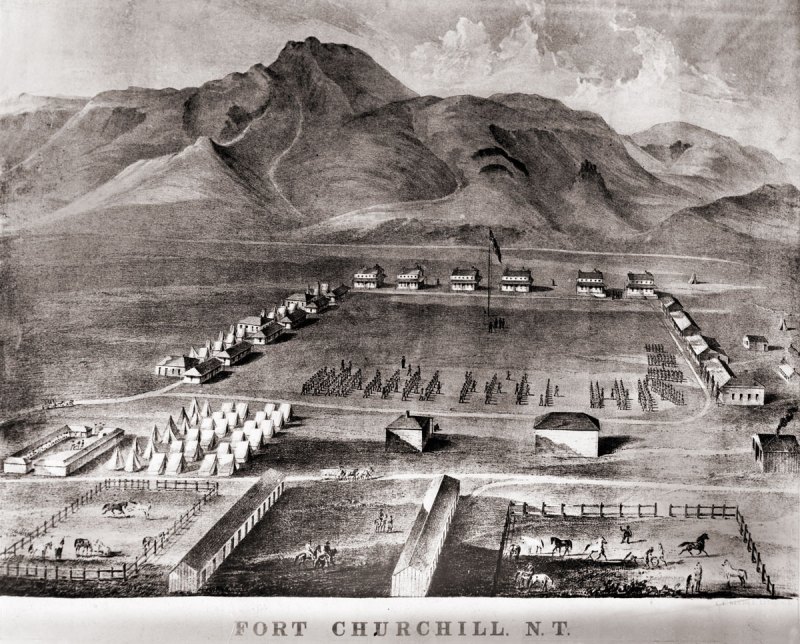
Fort Churchill is a Civil War era United States Army Fort, Pony Express Station and overland stage stop located in Lyon County, Nevada just West of Buckland’s Station. The station is designated as a home station, where extra horses, firearms, men and provision are kept. The fort was commissioned to protect early settlers from the east from Indian attacks. The garrison was the largest, most elaborate fortification in the Nevada Territory at the time.

A lithograph drawing of Fort Chuchill, Nevada Territory created by Grafton Tyler Brown in 1862

The discovery of gold in California caused a massive rush of people across the United States. Some of these early settlers came into the Nevada Territory and setup stage stops and mining operations. The arrival of settlers in their territory threatened the the Northern Paiute people. The increase populations of settlers increased the competition for local resources, such as game. These tensions, along with kidnapping and of rape of two young Paiute girls by prospectors from Williams Station erupted into Pyramid Lake War in 1860.

The U.S. Army fort was build along the Carson River and construction of Fort Churchill started on July 20, 1860. The base was named in honor of Sylvester Churchill who was the Inspector General of the Army. The fort is completed in early 1861 and home to some 200 soldiers charged with protecting settlers and mail routes. The post is abandoned in 1869.

On October 6, 1932, Nevada took control of the 200 acre fort and took steps to preserve the ruins as a state park.

Pony Express

Sources generally agree on the identity of Fort Churchill as a Pony Express stop. Built during the summer of 1860 by Captain Joseph Stewart and his men, the adobe fort housed the Pony Express station in its headquarters building. Construction on the fort began on July 20, 1860, approximately twenty-five miles from Comstock, Nevada, along the edge of the Carson River. When Richard Burton arrived at Fort Churchill on October 19, 1860, he gave it a positive review in his journal and named Captain F.F. Flint as the commander.

Since the Pony Express used Buckland’s as a home station, Fort Churchill probably assumed a similar function when the Pony Express transferred its station from Buckland’s to the fort. The Fort Churchill’s ruins existed as late as 1979, including the headquarters building, and it is a Nevada state park. 

Fort Churchill Map

NameFort Churchill
LocationChurchill County, Nevada
Other NamesFort Churchill Station
NPS Pony Express Station153
Next Westbound StationFairview Station
Next Eastbound StationBuckland’s Station
National Historic Landmark66000456

References

Ruby Valley Station

The Ruby Valley Station was started in 1859 as part of George Chorpenning’s mail route. Later the station served the Pony Express and Overland Mail Company line in White Pine County, Nevada. The station was managed by William “Uncle Billy” Rogers and Frederick William Hurst.

Ruby Valley, White Pine County, Nevada - Ruby Valley Pony Express Station - photo taken in 1944
Ruby Valley, White Pine County, Nevada – Ruby Valley Pony Express Station – photo taken in 1944

Richard Burton visited the site on October 7, 1860, Rogers served as stationkeeper. At that time, this station was considered a half-way point between Salt Lake City, Utah and the Carson Valley. Protection from angry Western Shoshone Tribes is provided from Fort Ruby from 1862 – 1869, which is located near by. The station is an extremely small log cabin which is just eleven feet wide and eighteen feet lone.

The area’s rich soil provided excellent opportunities to raise food and hay for the other stations along the route. A band of Shoshone and the army also established camps near the station at various times. Camp Floyd’s Company B of the 4th Artillery Regiment arrived at Ruby Valley in May 1860 to protect the mail route during the Pyramid Lake War and remained there until October. Thereafter, the station’s name appeared on the 1861 mail contract list.

NPS – Pony Express DIVISION FOUR: STATIONS BETWEEN SALT LAKE CITY AND ROBERTS CREEK

The structure is built from vertical logs which form the walls. The walls are topped by smaller logs placed perpendicularly to form a slightly sloped shed roof. The root is originally covered with sod. An exterior stone chimney stands at one end of the cabin. The only opening into the building is the front entrance, centered in the main facade. Pony Express stations consisted of rudimentary cabins for shelter, they were critical to the survival of the route.

For preservation, the Ruby Vally station was physically relocated to the grounds of the Northeastern Nevada Museum in Elko in 1960. The Northeastern Nevada Historical Society donated a brass maker to identify the station site in 1979. 

Ruby Valley Station Map

Station Summary

NameRuby Valley Station
LocationWhite Pine County, Nevada
Latitude, Longitude40.04652, -115.4918
GNIS845958
Elevation6030 feet
Pony Express Station No.131

References