Manzanar (Images of America)

Through a collection of vintage photographs, the Images of America series allows readers to explore the history that makes each city, town, or state unique.
East of the rugged Sierra Nevada in California’s Owens Valley lies Manzanar. Founded in 1910 as a fruit-growing colony, it was named in Spanish for the fragrant apple orchards that once filled its spectacularly scenic landscape. Owens Valley Paiute lived there first, followed by white homesteaders and ranchers. But with the onset of World War II came a new identity as the first of 10 “relocation centers” hastily built in 1942 to house 110,000 people of Japanese ancestry, two-thirds of them American citizens, removed from the West Coast. In the face of upheaval and loss, Manzanar’s 10,000 confined residents created parks, gardens, and a functioning wartime community within the camp’s barbed-wire-enclosed square mile of flimsy barracks.
Today Manzanar National Historic Site commemorates this and all of Manzanar’s unique communities.
About the Author
Author Jane Wehrey, a historian and Owens Valley native, also wrote Voices From This Long Brown Land: Oral Recollections of Owens Valley Lives and Manzanar Pasts and has been a consultant, park ranger, and exhibit writer at Manzanar National Historic Site. For this pictorial odyssey through Manzanar’s past, she compiled images from private and museum archives and from an extraordinary wartime record that includes photographs by Ansel Adams, Dorothea Lange, and former Manzanar internee Toyo Miyatake.
Book Summary
| Title | Manzanar (Images of America) |
| Author | Jane Wehrey |
| Publisher | Arcadia Publishing |
| Pages | 128 Pages |
Creek Dogwood (Cornus sericea)
Cornus sericea, commonly known as Redosier Dogwood, Red Twig Dogwood, or American Dogwood, is a deciduous shrub native to North America. It belongs to the family Cornaceae and is known for its striking red stems, especially visible in the winter, which provide ornamental value. This report explores the botanical characteristics, habitat, ecological significance, and uses of Cornus sericea.

Botanical Characteristics
Morphology
- Stems and Bark – The most distinctive feature of Cornus sericea is its bright red stems, which are particularly vibrant in young twigs. The bark is smooth and can be greenish-red in younger branches, turning grayish-brown with age.
- Leaves – The leaves are opposite, simple, and ovate to lanceolate, with a length of 5-12 cm. They have a smooth margin and are characterized by prominent venation. In the fall, the leaves turn a variety of colors including red, purple, and orange.
- Flowers – The flowers are small, creamy-white, and arranged in flat-topped clusters called cymes. Each flower has four petals and blooms from late spring to early summer.
- Fruit – The fruit is a small, white to bluish-white drupe, typically maturing in late summer. These drupes are an important food source for various bird species.
Growth and Reproduction
Cornus sericea can grow up to 1.5-4 meters in height and spreads through both seeds and vegetative means. It readily forms thickets by sending up new shoots from its root system. The plant prefers moist, well-drained soils but can tolerate a range of soil types including wet, clay soils.
Habitat and Distribution
Geographic Range
Cornus sericea is widespread across North America, from Alaska and Newfoundland south to New Mexico and Virginia. It thrives in a variety of habitats including wetlands, stream banks, and forest edges.
Environmental Preferences
This shrub prefers full sun to partial shade and thrives in moist, well-drained soils. It is often found in riparian zones, wetlands, and along the edges of lakes and rivers. Cornus sericea is adaptable to different soil types, including clay and sandy soils, and can tolerate seasonal flooding.
Ecological Significance
Wildlife Habitat
- Birds – The berries of Cornus sericea are a crucial food source for many bird species, including American robins, cedar waxwings, and woodpeckers. The dense thickets provide excellent cover and nesting sites for birds.
- Mammals – Small mammals, such as rabbits and beavers, feed on the bark and stems. The plant’s dense growth offers shelter for various small animals.
Erosion Control
Due to its extensive root system, Cornus sericea is effective in stabilizing soil and preventing erosion, especially along riverbanks and slopes. It is often used in riparian restoration projects for this reason.
Uses
Ornamental Use
Cornus sericea is widely planted as an ornamental shrub for its vibrant red stems, which provide winter interest in gardens and landscapes. It is also used in hedges, windbreaks, and as a natural screen.
Traditional and Medicinal Uses
Indigenous peoples of North America have historically used Cornus sericea for various purposes. The bark and stems were used in basket weaving, and the plant had medicinal applications, such as treating colds, fevers, and diarrhea.
Conservation and Restoration
Due to its ability to thrive in wet environments and stabilize soil, Cornus sericea is utilized in wetland restoration and conservation projects. It helps in maintaining biodiversity and improving water quality by filtering runoff.
Conclusion
Cornus sericea is a versatile and ecologically significant plant with wide-ranging benefits for wildlife, soil stabilization, and ornamental use. Its adaptability to different environments and its role in supporting biodiversity make it an important species in North American flora. Conservation and utilization of this shrub can contribute to sustainable environmental management and restoration efforts.
This report provides a comprehensive overview of Cornus sericea, highlighting its importance in various ecological and practical contexts. Further research and conservation efforts can enhance our understanding and utilization of this valuable plant species.
Resources
Scotty’s Castle (Images of America)

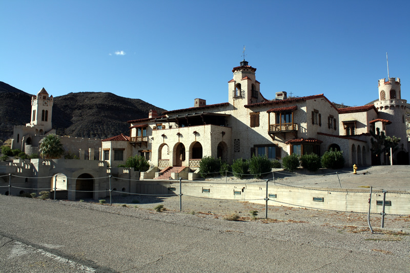
Scotty’s Castle is a study in contrasts, much like its setting in Death Valley. While the castle is known worldwide and has been visited by hundreds of thousands of tourists, many myths persist. It is not a castle, nor was it owned by Walter E. Scott, known as Death Valley Scotty. But the Spanish-style hacienda, also known as Death Valley Ranch, has always been linked to Scott. This book explores the fascinating history of Death Valley Scotty, Albert and Bessie Johnson (the true owners and builders of the castle), and the castle itself from construction to private living quarters to a tourist facility owned and operated by the National Park Service.”
About the Author
Robert P. Palazzo, Death Valley scholar and lifetime member of the area’s natural history association, evokes here in vintage imagery a stark, barren, desolate wasteland that gradually became one of the West’s most iconic destinations. Tapping his extensive private collection of rare photographs, Palazzo shows Death Valley’s geological features, notable personalities, industries, mysteries, and tourism. Though the area has changed little over the last 150 years, the harsh conditions have erased much of the evidence of human occupation. That rare visual record is preserved in these pages.
Book Summary
| Title | Scotty’s Castle (Images of America) |
| Author | Robert P. Palazzo |
| Publisher | Arcadia Publishing |
| Pages | 128 Pages |
Grand Canyon Railroad
The Grand Canyon Railroad is a 64 miles railroad which connects Williams Arizona to the South Rim of the Grand Canyon. The original 64 mile route was built by the Atchison, Topeka and Santa Fe Railway company in order to construct and promote the Grand Canyon Village. The railroad was completed on September 17th, 1901. in 1901 a ticket could be purchase for the sum of $3.95.

The El Tovar Hotel is completed in Janurary, 1905. The hotel is constructed by the Santa Fe Railway to accommodate train passengers and uniquely located just 20 feet from the Canyon Rim. The initial success of this railroad is diminished with the widespread adaptation of the automobile and the highway system. Passenger Service is halted in July 1968 and later freight service is halted in 1974.
In 1988, the line is purchased by Max and Thelma Biegert, who restored the railroad and started operations in 1989. The Biegerts made their fortune in Nevada, operated the line until 2006 when the railroad was again sold to Xanterra Travel Collection. Today, the railroad offers both diesel and steam engine service and operates as a Heritage Railway and gives the passenger a brief means of enjoying a by gone era.
The Polar Express
Every winter, following the release of the Christmas classic movie the Polar Express, the Grand Canyon Railway’s offers a special train serice, the Polar Express. The Polar Express is a 90 minute journey from the nighttime wilderness of Williams, Arizona, to “the North Pole”. During the journey, passengers are encouraged to sing and treated with hot chocolate and a reindeer bell.

Grand Canyon Railroad Map
Grand Canyon Railroad Summary
| Name | Grand Canyon Railroad |
| Location | Coconino County, Arizona Grand Canyon National Park |
| Years of Operation | September 17th, 1901 – Current |
| Gauge | Standard Gauge – 4 feet 8.5 inches (1,435 mm) |
| National Register of Historic Places | 00000319 |
References
Bodie and Benton Railway
The Bodie and Benton Railway operated for about thirty eights years, supplying the town of Bodie, California. The narrow gauge railroad travelled north, from the forests south of Lake Mead up to the townsite of Bodie.

The Bodie Railway and Lumber Company was founded on February 19th, 1881. The business plan called for supplying the town is lumber for building and firewood for heat against the harsh high altitude winters. Steam Engines, which powered the town, also burnt this valuable supply of fuel.
The lumber was collected from the Inyo National Forest south of Mono Lake. At the Mono Mills, the lumber is loaded onto flat cars before being hauled up to Bodie and Warm Springs and Line Kiln. The Mono Mills are capable of processing 80,000 board-feet of lumber in every 10 hours of operation.

The thirty one mile route up to Bodie also featured a two thousand foot elevation gain. The allow the rail to climb this grade, two switch backs are included in the route. The Bodie and Benton Railway is closed on September 7th, 1918. The need for a ready supply of fuel is diminished the a Hydroelectric Power Plant is constructed in Green Creek. The rail is abandoned and sold for scrap.
Today, there is little evidence of the railroad. An abandoned railcar was discovered and is now on display at the June Lake Marina.

Bodie and Benton Railway Map
Bodie and Benton Railway Summary
| Name | Bodie and Benton Railway |
| Also Known As | Mono Railway |
| Location | Mono County, California |
| Length | 31 miles |
| Gage | Narrow Gauge – 3 feet (914 mm) |
| Operations | February 19th, 1881 – September 7th, 1918 |


