
Big Bear, CA
I quiet mountain community full of back country adventure.
The Journey is the destination


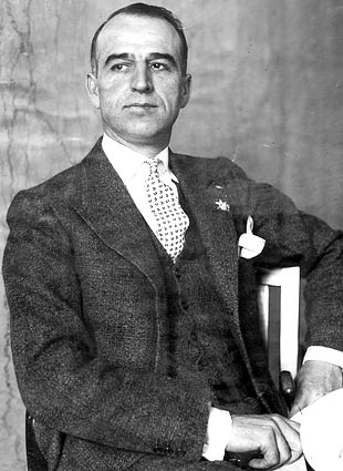
Doc Holliday, born John Henry Holliday, died on November 8, 1887, at the age of 36 in Glenwood Springs, Colorado. A dentist turned gambler and gunslinger, he suffered from tuberculosis for much of his life, which progressively worsened. By 1887, his health had deteriorated significantly, and he sought relief in the mineral springs of Glenwood Springs, hoping the warm waters might ease his condition. However, the disease, combined with his heavy drinking and frail state, led to his death in a sanatorium. Legend has it that his final words, upon looking at his bare feet and realizing he wasn’t dying in a gunfight, were, “This is funny.” He was buried in Linwood Cemetery overlooking Glenwood Springs.
News of Doc Holliday death was reported on November 10, 1887, by the Denver Republican.
Doc Holliday is dead. Few men have known better known to a certain class of sporting people and few men of his character had more friends or stronger champions. He represented a class of men who are fast disappearing the New West. He had the reputation of being a bunco-man, desperado and bad man generally. yet he was a very mild mannered man; was genial and companionable, and had many excellent qualities. In Arizona he was associated with the Wyatt Earp gang. These men were officers of the law, and were opposed to the ’‘rustlers” or cattle thieves. Holliday killed several men during his life in Arizona his body was full of wounds received in bloody encounters. His history was an interesting one. He was sometimes in the right, but quite often in the wrong, probably, in his various escapades.
The Doctor only had one deadly encounter in Colorado, and this was in Leadviile. He was well known in Denver and had lived here a good deal in the past few years. He had strong friends in some old-time detective officers and in certain representatives of the sporting element. He was a rather good looking man and his coolness and courage, his affable ways fund of interesting experiences, won him many admirers. He was a strong friend, a cool and determined enemy and a man of quite strong character. He has been well known to all the States and Territories west of Kentucky, which was his old home. His death took place at Glenwood Springs Tuesday morning.
Denver Republican.
The town of Rhyolite boasted three train services using the Rhyolite Train Depot which is completed in June, 1908. The depot services the Las Vegas & Tonopah, the Tonopah & Tidewater and the Bullfrog-Goldfield train services. The Las Vegas & Tonopah Railroad started its push to Rhyolite by laying one mile of track per day. Later, the railroad redoubled its efforts and pushed two miles per day its its bid to connect the booming two of Rhyolite with the outside world.

The first train entered Rhyolite at 7:00 pm on December 14th, 1906 bringing another 100 people into the town. Train service to the booming mining town was a big deal. The fact that Rhyolite could lure three train services all but ensured the future of the largest mining town in the state.
In 1907, the Las Vegas & Tidewater line alone hauled 50 freight cars per day into Rhyolite. This volume required a large depot to handle the load. In September 1907, the construction of the depot started by the Las Vegas & Tidewater Railroad. The Mission Revival styled building in constructed with concrete blocks built upon a solid concrete foundation. A gentlemen’s waiting area is located in the east end and a separate ladies waiting room is located in the west end. The ticket office is located in the center of the building and the ticket agents office is located on the second floor.
The train depot takes up an entire city block on Golden Street. The cost on construction was $130,000, or about $3.8 million in 2021.


The train depot in Rhyolite is complete in June 1908. The timing of the complete is ironic in that it coincided with the beginning on the decline of Rhyolite. Within months of completion of the depot, more people were leaving town using the station than arriving. In the first year of operation, the railroad generated a small profit. Between 1909 and 1919 the railroads lost money each year. By 1919, the railroads cut their losses and salvaged the tracks for other projects.
The 1920’s offered a brief revival to the town on Rhyolite. Wes Moreland purchase the train depot in 1935 and opened the Rhyolite Ghost Casino in 1937. Drinking and gambling are available on the first floor. The second floor operates as a brothel. The star of World Ware 2 halts the brief rebirth of Rhyolite. The fuel rationing almost completely drained the economy in the area.
In the 1960’s Moreland sister inherited the train depot. Mrs. Herschel Heiser operated a museum and gift shop out of the old station.
At the time it was built, the train depit is claimed to be “The finest in the state.” Today, the train station is one of the best preserved.
In keeping with its prominence as a mining center, Rhyolite was serviced by three railroads: the Las Vegas & Tonopah, the Tonopah & Tidewater, and the Bullfrog-Goldfield.
The Las Vegas & Tonopah Railroad laid one mile of track per day, then two miles of track per day, in its hurry to connect Rhyolite with the outside world. The first train from the Las Vegas & Tonopah entered Rhyolite at 7 p.m. on December 14, 1906, with about 100 passengers.
It was a big deal for a young mining town to be serviced by one railroad, but three railroads were almost unheard of in the history of Nevada. With three railroads, it seemed that Rhyolite was destined to be the largest mining camp in the state and the first few boom years made this prediction look inevitable.
By 1907, the Las Vegas & Tonopah alone was hauling 50 freight cars into town per day. The large volume of freight required a large depot to handle it.
In September 1907, the Las Vegas & Tonopah began building the depot that stands before you. It is constructed of concrete block with a solid concrete foundation in the Mission Revival style. There was a gentlemen’s waiting area on the east end and a ladies’ waiting room on the west end. A separate baggage room was located east of the men’s waiting area. The ticket office was located in the center of the building, and the ticket agent’s quarters were located upstairs.
It was planned to take an entire city block on Golden Street and cost approximately $130,000 – the equivalent of $3,798,393 in 2021.
The Las Vegas & Tonopah Railroad Depot was completed in June 1908, around the same time that Rhyolite began its slow decline. Within months of its completion, more people were leaving Rhyolite through the depot than were arriving.
The railroad turned a small profit in 1908 but lost money every following year until it was finally dismantled in 1919. The tracks were salvaged, but the depot was left to stand as one of the few remaining buildings from the Rhyolite boom, primarily because it could not be moved elsewhere.In the 1920s, Rhyolite enjoyed a small revival through tourism. Wes Moreland bought the depot in 1935 and, beginning in 1937, operated it as the Rhyolite Ghost Casino. The drinking and gaming were conducted downstairs, while a different type of hospitality, reportedly staffed by “working women,” was conducted upstairs in the old ticket agent’s quarters.
Like the town before it, the casino had a relatively short life. The onset of World War II, and the associated Rhyolite Train Depot Markerwar effort, including fuel rationing, completely drained the area’s economy.
By the 1960s, the building had passed to Moreland’s sister, Mrs. Herschel Heisler, who operated the lower floor as a museum and gift shop for tourists.Since the 1930s, the depot has passed from person to person, eventually ending up with the Barrick Mining Company.
In October 2000, the Bureau of Land Management (BLM) acquired the depot, along with most of the Rhyolite Townsite, from the mining company in a land swap.At some time before the swap, a group of local citizens replaced the historic depot roof with modern composite shingles. Although not historically accurate, the shingles have helped preserve the building in the relatively good condition that you see today.
At the time the depot was built, the local newspaper claimed it was “the finest in the state.” Today, it is one of the best-preserved examples of early twentieth-century Mission Revival train depots in Nevada.
The BLM’s Tonopah Field Office is working to restore this historic building. If you would like to donate to the restoration, a secure donation box is located to your right. All donations will be used in Rhyolite.
Please help us keep the depot in its current condition. Report acts of vandalism to the Tonopah Field Office at (775) 482-7800.
Leadfield California is a ghost town located in Inyo County and Death Valley National Park and found on the Titus Canyon Trail. The town boom in 1925 and 1926, however, Leadfield is a town that was started on fraud and deceit.

According to Legend and an article in Desert Magazine, and shameless promoter C. C. Julian wandered into Titus Canyon and started blasting tunnels. He then discovered lead ore which he purchased and brought down from Tonopah, Nevada. Julian then produced maps and other promotional materials and found investors from the East coast. The town of Leadfield was born and died on the imagination of this one man.
![Photograph of an exterior view of the Leadfield Hotel in Death Valley's Titus Canyon, [s.d.]. The hotel is a simple wooden structure with a slanted roof and a rectangular façade. The upper left corner of the façade is missing, revealing the interior of the building. Three large rectangular windows and two doors alternate across the front of the building. There are three people standing on a caved-in porch in front of the hotel. A large rocky mountain rises up behind the hotel. The hotel was part of C. C. Julian's Leadfield boomtown, the hey day of which was in 1925. Photo Credit “University of Southern California. Libraries” and “California Historical Society” as the source. Digitally reproduced by the USC Digital Library.](https://i0.wp.com/www.destination4x4.com/wp-content/uploads/2022/03/CHS-13040.jpg?ssl=1)
The truth of the tale is not quite as interesting or spectacular. According the the National Park Service, Leadfield ore was first worked in 1905. During the Bullfrog boom, which took place outside of Beatty, prospectors worked the land looking for the next big hit. In the fall of 1905, nine mine sights were identified and claimed by W. H. Seaman and Curtis Durnford. The ore from these sites was assayed in Rhyolite at $40 per ton. The men bought out a local consortium and the Death Valley Consolidated Mining Company was incorporated which released promotional material and sold shares for 2.5 cents each.
The mine and its ore did produce, however the Death Valley Consolidated Mining Company soon discovered that the expense of hauling the ore to Rhyolite and then the frieght costs to ship the material to smelters further off caused the ore to be not profitable. After six months of operation the Death Valley Colisidated Mining Company disappeared.


Despite early failures, in March of 1924 three prospectors wandered into the canyon and staked several claims. Ben Chambers, L. Christensen and Frank Metts worked their claims of lead ore for over one year before selling the claims to John Salsberry. Mr. Salsberry saw enough promise to form the Western Lead Mines Company and started to raise capital via stock sales at $0.10 per share. By the end of 1925, the Western Lead Mines Company was working 50 claims in the valley and soon began in invest in infastructure in the form of a compressor plant. A long steep road was constructed for LeadField to the Beatty Highway.
In early 1926, the Western Lead Mines Company build a boarding house and piped in water from a nearby spring. The town of Leadfield was named officially January 30th, 1926. Stock from the Western Lead Mines Company went on sale in January and within a 24 hour period, 40,000 share of stock were sold at $1.57 per share.
In February 1926 it became known to the public that C. C. Julian purchase shares and was now President of Western Lead Mines Company. Almost immediately the California State Corporation Commission began an investigation into the stock sale because a permit was not granted for the stock sale. The promoter went to work, along with several other mine operations, raise interest and money for the town. City plans were filed with Inyo County, however the spectre of investigation loomed.

Despite the arrival of a post office, investment into the location, and hundreds of feet of tunnel, C. C. Julian was ordered to cease sale of stock by the California State Corporation Commission. Around the same time, the primary tunnel of the Western Lead Mines Company penetrated to the ledge which experts predicted the highest quality ore. This ore was assayed at 2% and far too low for profit considered freight costs.

Leadfield and the surrounding mines where gone months later. Mr. Julian was blamed despite the facts that he did not start the venture, there was ore at the location, and he invested money and time towards the venture. Once his Leadfield venture faltered, he moved onto to Oklahoma and was caught up in yet another scam. Julian later fled the country for Shanghai in March of 1933 m where he committed suicide in 1923 after several more failed schemes. Julian was buried in a beggers coffin and his funeral was attended by nine people.
Mr. Julian is responsible for the road through Titus Canyon, which many is a favorite route of visitors every year.

For a detailed history, the NPS offers a great article.
| Name | Leadfield |
| Location | Inyo County, Death Valley, California |
| Latitude, Longitude | 36.8466107,-117.0592307 |
| GNIS | 1658952 |
| Elevation | 4000 feet |
| Newspaper | Leadfield Chronicle ( 192?-19?? ) |
| National Register of Historic Places | 75000221 |
Founded in 1865 when Brigham Young sent settles to the confluence of the Virgin River and Muddy Rivers. St Thomas Nevada remained a Mormon settlement until 1871 when a surveying correction placed the town in Nevada. When the Mormons abandoned the area, other settlers claimed the property. St Thomas used to served as a pit stop for travelers between Los Angeles, California and Salt Lake City, Utah using along the old Arrow Highway (US 91).

The United States Federal Government “purchased” the land as part of the Hoover Dam project. In actuality, there were multiple suits as the residents of St. Thomas raise complaints about the amount the federal government was paying for their land. In time, the residence lost and the entire town was doomed to its destiny and the water of Lake Mead continued to rise.

The last known resident as Hugh Lord, who remained until the water surrounded his home. He loaded is possessions into a row boat, set fire to his home, and rowed off into history. Soon the rising water of Lake Mead swallowed the entire down, and wasted the landscape with water 60 feet deep. From time to time, the lake level will drop low enough to expose this lost town.
The town is currently exposed, and lies in the lake bed surrounded by a large expanse of tamarisk. The dirt road to the trail-head is located just inside the entrance to Lake Mead National Recreation Area when coming from Moapa and Overton and the trail is beyond simple and suitable for almost every vehicle.

The 2.5 miles hiking trail is very easy and takes you from the trail-head and loops through the town. The trail would be a bit more difficult if you attempt the trail during the hot summer months. Remains of the town are limited to foundations, some old wood fence posts and some metal artifacts such as farming equipment and a V-8 small block. The park service appears to cut the tamarisk back to expose the foundations for visitors, however the cut off tamarisk trucks can be a tripping hazard and would be harsh it you fell on one, so keep in eye on where you step.

I have been to many ghost towns over the years. Many of them lost in history due to mines failing to produce, fire, hard environments and disease. St Thomas is different from all the others. This is a ghost town by design, by protest and there is no better reminder than the fresh water clam shells which litter the site. The fact that there are viable towns (Moapa and Overton) just a few miles away make St Thomas all the more poignant.

Located just outside of Page, Arizona Upper Antelope Canyon is arguably the best known slot canyon on the planet, yet few people will know its name outside of desert enthusiasts. For those unaware of these structures, slot canyons are extremely narrow canyons, carved by water, which are typically just a few feet wide, but may be just a few inches. The typically arid dessert can instantly turn into raging torrent of water in just a few minutes with just a few inches of water. This water picks up speed, and debris such as sand, which scours the landscape including rock. Antelope Canyon is found on Navajo Tribal land, and access to the canyon is only allowed with a Navajo Guide.


Antelope Canyon is actually two separate slot canyons located a short distance from each other on either side of US 98. Upper Antelope Canyon is know as Tse’ bighanilini, which in Navajo means “the place where water runs through rocks.” Travel to the Canyon is done via Navajo run transport and you are allowed about 2 hours for your visit. The site is at about 4,000 feet elevation and the canyon walls rise 120 feet above a stream bed.
I would like to thank the LeChee Chapter of the Navajo Nation for keeping this location sacred and available to us.
James Rathbun, Destination4x4.com
Access into the upper canyon is simply a walking into a canyon. The trail is flat and sandy and very easy to manage. Upon entrance into the Upper Antelope Canyon you are immediately struck by the texture and color of this place. Just inside the entrance, is a small chamber which seems to great you, and the pink and orange glow of the light bouncing off the walls force your eyes up. The geography is such, that the narrow opening high above you lets in a small fraction of the available light, and that light bounces down towards the bottom of the canyon.
Relatively short, Upper Antelope Canyon may be traversed in just 5 minutes. However, this is simply a waste of your time if you just rush through. The only complaint of the canyon, are the other visitors. As a photographer, I have many photographs ruined by people turning a corner and walking into my frame while I was making an exposure. This does not mean they were rude or anything but patient, but rather an unfortunate side effect of composing photographs with long exposure times in a 18 inch wide slot Canyon.

As with all beautiful things, we must share this location and Antelope Canyon is a must stop location every time I visit the area. There is a hidden danger, in that the very forces which sculpt a slot canyon are still very much in play and every few years a new story will appear about someone being killed in a slot canyon due to a sudden flash flood.
I would like to thank the LeChee Chapter of the Navajo Nation for keeping this location sacred and available to us.