Raven ( Corvus corax )
The Raven ( Corvus corax ) is one of eight subspecies of Ravens distributed throughout the world. Also known as western or northern raven, this large black bird is a member of the Corvidae family of birds which also contains crows, jays and magpies. This bird is a rather large and features solid black feathers which offers a dramatic and ominous appearance.
The raven is a large bird, known to average 25 inches in length and 2.6 pounds in weight and heaviest of the passerine or perching birds. This species is renowned for its intelligence and commonly used to test animal problem solving ability. This species has a world wide distribution and can thrive in a large variety of climates. The bird is an opportunistic omnivore finding sources of nutrition, feeding on carrion insects, grains, berries, fruit, small animals, other birds, and food waste. The are common features around campgrounds for the food sources left by human activity.

The raven has a long history with man in culture, literature and superstition. Many Native American tribes cultures regard the bird as a trickster or a cosmic messenger. Edgar Allen Poe’s infamous poem forever linked this bird with ominous overtones and symbolism for in western culture. The National Football Team even has a football team named for this special mischievous bird.
Field Guide Description
“Large with a long, heavy bill and long wedge-shaped tail. Most common call is a low drawn-out croak. Larger than the Chihuahuan Raven; note thicker, shaggier throat feathers, and that nasal bristles to not extend as far our on the larger bill. Range: Found in a variety of habitats, including mountains, deserts, coastal areas. Numerous in western and northern part of range; uncommon and local, but spreading in Appalachians.”
Field Guide to the Birds of North America, Third Edition, pg 318
Classification
| Kingdom | Animalia |
| Phylum | Chordata |
| Class | Aves |
| Order | Passeriformes |
| Family | Corvidae |
| Genus | Corvus |
| Species | corax |
References
Oreana Nevada – Pershing County Ghost Town
Oreana Nevada is a milling town which was active from 1865 – 1885 in Pershing County Nevada and home to the Montezuma Smelting Works. The townsite is located on Interstate 80 / U.S. 95 about fourteen miles north east of Lovelock.

In 1865 a five stamp mill was relocated from Trinity and located on the eastern bank of the Humboldt River. This mill is used to process ore from the nearby Montezuma mine and the Arabia district.
In 1857 the Montezuma Smelting Works is built in Oreana, Nevada by the Trinity and Sacramento Company. The location of the smelting works is a bold choice for its Superintendent A. W. Nelson, who built the factory, which contained eight furnaces if a location with little fuel. The nearby mining districts of Arabia and the Trinity mining district were the primary source of ore to supply the plant with raw materials.

A hotel, boarding houses, post office, restaurants, meat market and general store kept the citizens feed and houses. In addition to mining and smelting, a livery and blacksmith and kept them working. The Oreana Jockey Club kept them entertained by sponsoring horses races. So long as the mines produced ore, the smelters processed it 24 hours a day.
At the time, Oreana is the largest in the Humboldt Valley. This title would later be taken by Lovelock, Nevada. Despite its solid foundations, Oreana found itself in financial trouble. Debt and Taxes caused a shutdown in 1869. And again in 1871. Today not much remains to indicate a town.
Oreana Town Summary
| Name | Oreana Nevada |
| Location | Pershing County, Nevada |
| Latitude, Longitude | 40.310833, -118.370556 |
| GNIS | |
| Elevation | 4160 Feet |
| Post Office | February 1867 – July 1869 February 1870 – September 1873 October 1873 – March 1883 |
Oreana Map
References
Fort Churchill Nevada
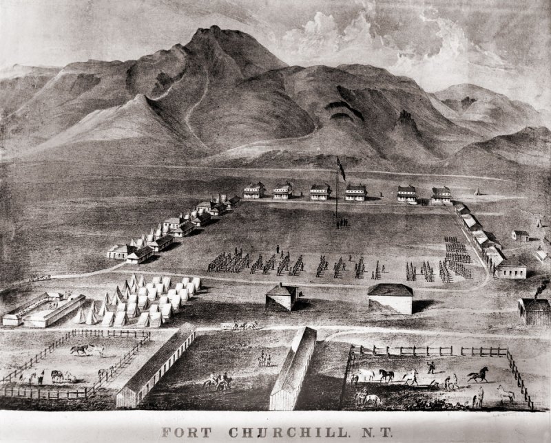
Fort Churchill is a Civil War era United States Army Fort, Pony Express Station and overland stage stop located in Lyon County, Nevada just West of Buckland’s Station. The station is designated as a home station, where extra horses, firearms, men and provision are kept. The fort was commissioned to protect early settlers from the east from Indian attacks. The garrison was the largest, most elaborate fortification in the Nevada Territory at the time.

The discovery of gold in California caused a massive rush of people across the United States. Some of these early settlers came into the Nevada Territory and setup stage stops and mining operations. The arrival of settlers in their territory threatened the the Northern Paiute people. The increase populations of settlers increased the competition for local resources, such as game. These tensions, along with kidnapping and of rape of two young Paiute girls by prospectors from Williams Station erupted into Pyramid Lake War in 1860.
The U.S. Army fort was build along the Carson River and construction of Fort Churchill started on July 20, 1860. The base was named in honor of Sylvester Churchill who was the Inspector General of the Army. The fort is completed in early 1861 and home to some 200 soldiers charged with protecting settlers and mail routes. The post is abandoned in 1869.
On October 6, 1932, Nevada took control of the 200 acre fort and took steps to preserve the ruins as a state park.
Pony Express
Sources generally agree on the identity of Fort Churchill as a Pony Express stop. Built during the summer of 1860 by Captain Joseph Stewart and his men, the adobe fort housed the Pony Express station in its headquarters building. Construction on the fort began on July 20, 1860, approximately twenty-five miles from Comstock, Nevada, along the edge of the Carson River. When Richard Burton arrived at Fort Churchill on October 19, 1860, he gave it a positive review in his journal and named Captain F.F. Flint as the commander.
Since the Pony Express used Buckland’s as a home station, Fort Churchill probably assumed a similar function when the Pony Express transferred its station from Buckland’s to the fort. The Fort Churchill’s ruins existed as late as 1979, including the headquarters building, and it is a Nevada state park.
Fort Churchill Map
| Name | Fort Churchill |
| Location | Churchill County, Nevada |
| Other Names | Fort Churchill Station |
| NPS Pony Express Station | 153 |
| Next Westbound Station | Fairview Station |
| Next Eastbound Station | Buckland’s Station |
| National Historic Landmark | 66000456 |
References
Stellars Jay ( Cyanocitta stelleri )
The Stellars Jay ( Cyanocitta stelleri ) is a common character found in the forests of the western half of the United States. The bird is an opportunistic omnivore and closely related to the Blue Jay. The Stellars Jay has a black crested head and a vibrant blue body which is commonly about between eleven and twelve inches long. This bird has a lot of variations depending on location.

The Stellars Jay is commonly, mistakenly, called a “Blue Jay” in the Pacific Northwest. The Stellar, however, is a distinct species from the Blue Jay ( Cyanocitta cristata ). The major differentiating characteristic is the Blue Jay does not have a crest.

This bird commonly feeds upon seeds, nuts and acorns. Speaking from first hand information, they also love unsalted peanuts. The will also eat insects and other small invertebrates, including mammals. They are also known to raid other birds nests and can be very aggressive with other birds.
Stellars Jay breed in monogamous pairs and a clutch of eggs is typically 3 – 5 in number. Both parents are active is feeding the young.
Distribution
The Stellar’s Jay is a common bird located primarily in pine-oak woodlands and coniferous forests. The dark blue and black coloring of the species helps aid in camouflage in the shadows of the forest.
The species is fairly bold and aggressive in its behavior and it is quite common to encounter them around campgrounds and picnic areas.
This animal is found across most of the western states. The bird is known to cross breed with the Blue Jay when their ranges overlap.
The range of this bird is as far north as Alaska and to the south in Nicaragua. The Eastern boundary in the United States for this bird is Colorado and New Mexico.

Field Guide Description
“Crested; dark blue and black overall. Some races, including nominate from coast to northern Rockies are darker backed; have blueish streaks on forehead. Central and southern Rockies race, C.s. macrolopha, have long crest, paler back, white streaks on forehead, white mark over eye; largest race, carlottae, resident of Queen Charlotte Island off British Columbia, is almost entirely black above. Where ranges overlap in the eastern Rockies, Stellar’s Jay occasionally hybridizes with Blue Jay. Calls include a series of shack or shooka notes and other calls suggestive of Red-tailed Hawks. Range: Common in pine-oak woodlands and coniferous forests. Bold and aggressive; often scavenges at campgrounds and picnic areas. Casual winter visitor of lower elevations of the Great Basin, southern California and southwestern deserts.”
Field Guide to the Birds of North America, Third Edition, pg 312
Classification
| Kingdom | Animalia |
| Phylum | Chordata |
| Class | Aves |
| Order | Passeriformes |
| Family | Corvidae |
| Genus | Cyanocitta |
| Species | cristata |
References
Furnace Creek Campground
Furnace Creek Campground is located at -200 below sea level in Death Valley National Park, California. The campground is the most popular in the Death Valley and reservations are strongly recommended. The campground is located just off Highway 190 near Furnace Creek.

Furnace Creek Campground is the lowest in the park in terms of elevation, and located near the hottest measured temperature on the plant. Close to a lot of amenities , such as a store, borax museum & gas station, this campground offers a central location to scout out and explore Death Valley. All of the campsites feature tables, fire rings, water and flush toilets. This is a wonderful location for sky gazers who seek a clear night sky with little light pollution.
Death Valley frequently experiences temperatures over 120° F and in addition to holding the all time hottest temp (134° F – July 10, 1913) Death Valley routinely records some of the hottest days on the planet year after year. All to frequently, a visitor will die in this area due to the very extreme heat, plan your trip with care and mind the heat. One more that one occasion, I have been in the park with the temperature being north of 125° F.
Artist Drive, Badwater and Zabriskie Point and all located a short drive from this little oasis. The local gas station is always a quick stop for us when we drive by, so we can star in horror at the high price of fuel, which is typically $2 per gallon higher than outside of the National Park.
Campground Summary
| Name | Furnace Creek Campground |
| Location | Furnace Creek, Death Valley National Park, California |
| Latitude, Longitude | 36.463188,-116.8710673 |
| Elevation | -200 feet |
| Number of Sites | 136 |
| Amenties |
Furnace Creek Campground Map
References
- Recreation.gov
- NPS.gov


