Ragtown Nevada

Ragtown Nevada is ghost town and Nevada State Historical Marker number nineteen. The town and Nevada State Historic Marker are located in the Churchill County, Nevada. The town was located about eight miles west of Fallon Nevada. Originally, the town was located near Leeteville, but later is relocated to its historic location. Today, nothing remains of the old settlement.

Ragtown Nevada
Ragtown, Nevada

The site which will become Ragtown started in 1854 as a station along the Humboldt Overland Trail. The station is located on a small ranch and the site is the first watering hole for travelers west of the dry alkali Forty Mile desert. The Forty Mile desert is one of the most notorious sections of the transit and the site of many tragedies. Travelers would rest and recoup from the journey along the northern bank of the Carson River before starting for the Sierra Nevada. The name Ragtown comes from the clothing hung to dry from the women doing their laundry.

During the late 1850’s, small structures are built from willow poles and canvas as temporary shelters for travelers. A summer seasonal population is comprised of traders, gamblers and those of less notable reputation. Samuel Clemmons visited Ragtown in 1861 on his way out west.

A flood in 1862 destroyed all of the structures and disinterred some 200 graves. The site is temporarily abandoned until the Reese River Excitement in 1863 started a renewal. By the late 1860s a post office is established and the small population of farmers worked the area. The location is bypassed with the establishment of the Central Pacific rail service.

Today, nothing remains of Ragtown beyond a historic maker.

Nevada State Historic Marker Text

Ragtown was never a town. Instead, it was the name of a most welcome oasis and gathering point. This mecca on the banks of nearby Carson River received its name from the appearance of pioneer laundry spread on every handy bush around.

The Forty Mile Desert, immediately to the north, was the most dreaded portion of the California Emigrant Trail. Ragtown was the first water stop after the desert. To the thirst- crazed emigrants and their animals, no sight was more welcome than the trees lining the Carson River.

Accounts tell of the moment when the animals first picked up the scent of water—the lifted head, the quickened pace, and finally the mad, frenzied dash to the water’s edge. Then, emigrants rested for the arduous crossing of the Sierra Nevada that lay ahead.

In 1854, Asa Kenyon located a trading post near Ragtown, offering goods and supplies to travelers during the 1850s and 1860s. Ragtown was one of the most important sites on the Carson branch of the California trail.

HISTORICAL MARKER No. 19
STATE HISTORIC PRESERVATION OFFICEC
HURCHILL COUNTY MUSEUM COMMITTEE

Nevada State Historical Markers identify significant places of interest in Nevada’s history. The Nevada State Legislature started the program in 1967 to bring the state’s heritage to the public’s attention with on-site markers. Budget cuts to the program caused the program to become dormant in 2009. Many of the markers are lost of damaged.

Historic Photos

Desert Lake, near Ragtown, Western Nevada, ca. 1867 by Timothy H. O'Sullivan
Desert Lake, near Ragtown, Western Nevada, ca. 1867 by Timothy H. O’Sullivan

Pony Express

Townley identifies Ragtown as a station between Old River and Desert Wells. Like other stations on the “Stillwater Dogleg,” Ragtown probably functioned briefly as a Pony Express station in the summer and fall of 1861 and as an Overland Mail Company stage stop from 1861 to 1868. L. Kenyon and his family managed station operations at the site for nearly fifty years. The station’s name supposedly came from the common site of freshly washed travelers’ clothing spread out to dry on surrounding bushes.

Ragtown Summary

NameRagtown, Nevada
LocationChurchill County, Nevada
GNIS
PopulationTransitory, Seasonal, 50
Post Office186X –
Elevation4,029 feet
Nevada State Historic Marker19
Latitude, Longitude39.5057,-118.9215
NPS Pony Express Station160
Next Westbound StationDesert Wells Station
Next Eastbound StationNevada Station

Nevada State Historic Marker Map

References

Fort Churchill Nevada

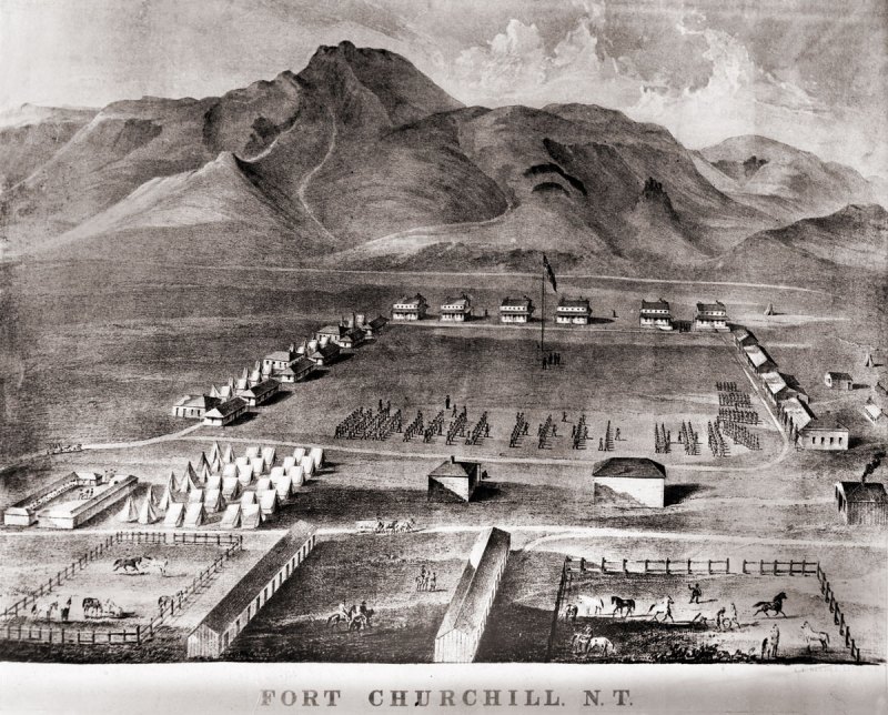
Fort Churchill is a Civil War era United States Army Fort, Pony Express Station and overland stage stop located in Lyon County, Nevada just West of Buckland’s Station. The station is designated as a home station, where extra horses, firearms, men and provision are kept. The fort was commissioned to protect early settlers from the east from Indian attacks. The garrison was the largest, most elaborate fortification in the Nevada Territory at the time.

A lithograph drawing of Fort Chuchill, Nevada Territory created by Grafton Tyler Brown in 1862

The discovery of gold in California caused a massive rush of people across the United States. Some of these early settlers came into the Nevada Territory and setup stage stops and mining operations. The arrival of settlers in their territory threatened the the Northern Paiute people. The increase populations of settlers increased the competition for local resources, such as game. These tensions, along with kidnapping and of rape of two young Paiute girls by prospectors from Williams Station erupted into Pyramid Lake War in 1860.

The U.S. Army fort was build along the Carson River and construction of Fort Churchill started on July 20, 1860. The base was named in honor of Sylvester Churchill who was the Inspector General of the Army. The fort is completed in early 1861 and home to some 200 soldiers charged with protecting settlers and mail routes. The post is abandoned in 1869.

On October 6, 1932, Nevada took control of the 200 acre fort and took steps to preserve the ruins as a state park.

Pony Express

Sources generally agree on the identity of Fort Churchill as a Pony Express stop. Built during the summer of 1860 by Captain Joseph Stewart and his men, the adobe fort housed the Pony Express station in its headquarters building. Construction on the fort began on July 20, 1860, approximately twenty-five miles from Comstock, Nevada, along the edge of the Carson River. When Richard Burton arrived at Fort Churchill on October 19, 1860, he gave it a positive review in his journal and named Captain F.F. Flint as the commander.

Since the Pony Express used Buckland’s as a home station, Fort Churchill probably assumed a similar function when the Pony Express transferred its station from Buckland’s to the fort. The Fort Churchill’s ruins existed as late as 1979, including the headquarters building, and it is a Nevada state park. 

Fort Churchill Map

NameFort Churchill
LocationChurchill County, Nevada
Other NamesFort Churchill Station
NPS Pony Express Station153
Next Westbound StationFairview Station
Next Eastbound StationBuckland’s Station
National Historic Landmark66000456

References

The Pony Express Trails and Stations In Nevada

The Pony Express operated for a very brief period of time from April 3, 1860, to October 26, 1861. The mail service allowed quick delivery of mail, messages and newspapers between California and Missouri. The pony express was built and operated around one hundred and eighty six stations, which enabled a rider to change horses frequently and quickly traverse the county.

Pony Express Riders "Billy" Richardson, Johnny Fry, Charles Cliff, Gus Cliff - Ernest and Elaine Hartnagle (original tintype from the Martin E. Ismert Collection - Kansas City, Missouri) - http://www.historybuff.com/library/refrichardson.html
Pony Express Riders “Billy” Richardson, Johnny Fry, Charles Cliff, Gus Cliff – Ernest and Elaine Hartnagle (original tintype from the Martin E. Ismert Collection – Kansas City, Missouri) – http://www.historybuff.com/library/refrichardson.html

The Pony Express only operated for a brief 18 months. Yet, the lore of its riders racing the mail across the country maintains a special place in history. The service was not a financial success and heavily subsidized. Despite this influx of capital, the service was doomed on October 24, 1861 with the success of the transcontinental telegraph.

A Brief History

The Pony Express started to fill a need caused by the growing populations of California. After the discovery of Gold in 1848, thousands streaked to the golden state to seek their fortune in the ground. Additional demand for mail service was caused from migration along the infamous Oregon Trail and the Utah Mormon exodus in 1847. Stage Service was used to transfer correspondence across the Western United States.

Pony express route April 3, 1860 - October 24, 1861 - Jackson, William Henry, 1843-1942.
Pony express route April 3, 1860 – October 24, 1861 – Jackson, William Henry, 1843-1942.

The service was built and organized by three men, William Russell, Alexander Majors, and William B. Waddell. These men formed the company Russell, Majors & Waddell and in just two months in the winter of 1860 organized 184 stations, 80 riders and 400 hundred horse to race mail from St. Joseph, Missouri to Sacramento, California. Some of the stations were existing stage stops while others were purpose built humble buildings deep in the Nevada territory. They hoped with a 10 day delivery time they could secure government contracts. The costs of the expedited service was 25000% greater that the slower stage service and a 1/2 package would cost $5 at the time.

“Men Wanted”

The undersigned wishes to hire ten or a dozen men, familiar with the management of horses, as hostlers, or riders on the Overland Express Route via Salt Lake City. Wages $50 per month and found.

Ad in the Sacramento Union, March 19, 1860

The riders would received their delivery and store them in a special mail pouch or mochila. The rider would travel from station to station and changed horses at each station about every 10 miles. Every third station, or so, is designated as a home station, where extra horses, firearms, men and provision are kept. Weight was an important factor. Riders, horses, letters, and gear were all chosen with this in mind. The horses averaged about 14 1/2 hands high and weighed less than 900 pounds. The riders would be changed every 75 to 100 miles and road 24 hours a day. A pony express rider earned $125 / month which was a good salary for the time

The last day of the pony express was October 26, 1861. On this day, the transcontinental telegraph completed the first direct communication between san Francisco and New York. On that day, the pony express officially became too slow, too expensive and ceased operations.

Illustrated Map of Pony Express Route in 1860 by William Henry Jackson ~ Courtesy the Library of Congress ~ The Pony Express mail route, April 3, 1860 – October 24, 1861; reproduction of Jackson illustration issued to commemorate the 100th anniversary of Pony Express founding on April 3, 1960. Reproduction of Jackson's map issued by the Union Pacific Railroad Company.
Illustrated Map of Pony Express Route in 1860 by William Henry Jackson ~ Courtesy the Library of Congress ~ The Pony Express mail route, April 3, 1860 – October 24, 1861; reproduction of Jackson illustration issued to commemorate the 100th anniversary of Pony Express founding on April 3, 1960. Reproduction of Jackson’s map issued by the Union Pacific Railroad Company.

Nevada Pony Express Stations

Pony Express Rider Oath

I, … , do hereby swear, before the Great and Living God, that during my engagement, and while I am an employee of Russell, Majors, and Waddell, I will, under no circumstances, use profane language, that I will drink no intoxicating liquors, that I will not quarrel or fight with any other employee of the firm, and that in every respect I will conduct myself honestly, be faithful to my duties, and so direct all my acts as to win the confidence of my employers, so help me God.”

Oath sworn by Pony Express Rider

Pony Express Trail Map

Buckland Station early 1900s

Buckland’s Station

Buckland Station is a pony express station, stage stop, boarding house and supplier near Fort Churchill in Lyon County, Nevada. The station is designated as…
King Street, General View, 1880, Carson City, Carson City, NV

Carson City Station – Pony Express Station

Carson City Station was a pony express station located between on Carson Street between Forth and Fifth Street in Carson City, Nevada. Founded in 1858,…

Dayton Station – Pony Express

Dayton, Nevada is a small unincorporated community, and the location of the Dayton Station Pony Express stop in Lyon County, Nevada. The little town of…
Diamond Springs Station

Diamond Springs Station

Diamond Springs Station is a Pony Express Station number 133 and located in a meadow in Eureka County, Nevada. Today the station is on private…
Nevada Hills Gold Mine, Fairview, Nevada

Fairview Nevada – Churchill County Ghost Town

Founded in 1905, Fairview Nevada is a ghost town and silver mining camp located in Churchill County, near the town of Fallon, Nevada. The towns…
A lithograph drawing of Fort Chuchill, Nevada Territory created by Grafton Tyler Brown in 1862

Fort Churchill Nevada

Fort Churchill is a Civil War era United States Army Fort, Pony Express Station and overland stage stop located in Lyon County, Nevada just West…
Friday's Station was a Pony Express station at Lake Tahoe - (Nevada Historical Society

Friday’s Station – Pony Express

Friday's Station is Union Army Military Post and Pony Express Station located near Lake Tahoe, in Douglas County, Nevada. The two story building is originally…
Simpson expedition, Genoa, Nevada, 1859

Genoa Station – Pony Express

Originally part of the Utah Territory, Genoa is a former Pony Express Station and unincorporated community in Douglas County, Nevada. The settlement was first founded…
Winchester Firearms adopted the image of a Pony Express Rider.

Miller’s Station – Pony Express

Miller's station, also known as Reed's Station is a pony express station located in Churchill County, Nevada. Winchester Firearms adopted the image of a Pony…
Ragtown, Nevada

Ragtown Nevada

Ragtown Nevada is ghost town and Nevada State Historical Marker number nineteen. The town and Nevada State Historic Marker are located in the Churchill County,…
Ruby Valley, White Pine County, Nevada - Ruby Valley Pony Express Station - photo taken in 1944

Ruby Valley Station

n was started in 1859 as part of George Chorpenning's mail route. Later the station served the Pony Express and Overland Mail Company line in…
Pony Express Riders "Billy" Richardson, Johnny Fry, Charles Cliff, Gus Cliff - Ernest and Elaine Hartnagle (original tintype from the Martin E. Ismert Collection - Kansas City, Missouri) - http://www.historybuff.com/library/refrichardson.html

The Pony Express Trails and Stations In Nevada

The Pony Express operated for a very brief period of time from April 3, 1860, to October 26, 1861. The mail service allowed quick delivery…
Van Sickle's Station 1870

Van Sickle’s Station – Pony Express

The Van Sickle's Station is the second Pony Express Station encountered when traveling east from Friday’s Station at the California/Nevada State Line. The Van Sickle…

References

Jessup Nevada – Churchill County Ghost Town

Jessup Nevada is a ghost town and gold mining camp located in Churchill County, Nevada. The site was first discovered in February 1908 by Frank Jessup & L. H. Murray.  The town is located about 4 miles northwest of the I-80 and even has an offramp used to access the town site. The mineralization was believed to be an extension of the mineralization from Seven Troughs in Pershing County.

Early days in Jessup, 1908 - Unknown photographer - Stanley W. Paher, Nevada Ghost Towns & Mining Camps, Howell North, (1970), p 112, Mrs. R.R. Purdy collection
Early days in Jessup, 1908 – Unknown photographer – Stanley W. Paher, Nevada Ghost Towns & Mining Camps, Howell North, (1970), p 112, Mrs. R.R. Purdy collection

Initially, rich gold ore valued at $100 per ton was hauled from the site using automobiles. When the tents started to from the city, the district is described as “forging ahead” by nearby newspapers. The town supported its 300 citizens from eight active mines. The small town supported three grocery stores, two lumbers, seven saloons and a meat market. For those who do not want to do the math, that is one saloon for every 43 citizens. In April, 1908 the Reno Evening Gazette reported lumbered being shipped to the mine camp by the carload and that the mining tents were being replaced with wooden structures. The completion of the Hotel and other larger structures was slowed by wood shortages.

During its heyday, people could reach the town by travelling by train to Huxley and then jumping on the daily stage service. A new road was petitioned to the county to connect to nearby Miriam. This new route would allow heavy freight to be shipped from the railroad without crossing the muddy, rough crossing salt flats.

One year after its start, Jessup was on the declined after the initial boom faltered in the fall of 1909. Investment continued into the mines and the area, however it was clear the time of Jessup was past.

Town Summary

NameJessup Nevada
LocationChurchill County, Nevada
Latitude, Longitude39.948611, -118.875
Elevation4550 Feet
Population300
Post OfficeMarch 1908 – July 1912
Continue Reading →

La Plata Nevada – Churchill County Ghost Town

Following the discovery of silver in 1862, La Plata Nevada is a ghost town locate in and the second county seat of Churchill County, Nevada. The site is found on the eastern slope of the Still Water Range about thirty miles East of Fallon. The town was founded at the convergence of La Plata Canyon and Silver Wave Canyon. The name of the town and the canyon is derived from the Spanish word for silver.

This ten-stamp mill built in 1864 at the lower end of La Plata - Nevada Ghost Towns and Mining Camps - Paher
This ten-stamp mill built in 1864 at the lower end of La Plata – Nevada Ghost Towns and Mining Camps – Paher

The mines of La Plata were not overly successful. Despite investment from eastern capitalists, wide area prospecting resulted in discouraging results. The Silver Wave Mining Company owned the townsite and a 1500-acre ranch. The mining company start a small mill in anticipation of profitable ore.

The town was the second county seat of Churchill County from 1864 until 1868. The court house was a converted structure purchase for $700 from Anton Kaufman on on October 15, 1864. The townsite climate was described as “delightful, atmosphere pure, bracing, and wholesome” by the Hon. George W. Stein, of Easton, Pennsylvania, President of the “Silver Wave Company,”

The town hosted a Post Office, the mills and a few businesses, including the Warren House, the La Plata Hotel and Pioneer Saloon. The town was V-shaped due its location at the convergence of two canyons. Plans were made for a much larger townsite, however, the ore simply did not support the plans. A special election was held on October 22, 1867 and as a result the county seat was was moved to the town Stillwater, in 1868.

There was a short revival of La Plata mines in the spring of 1906, but a revival was not in the forecast for this location.

Town Summary

NameLa Plata
LocationChurchill County, Nevada
Latitude, Longitude39.449350216615784, -118.31154064991719
Eleation5280 ft
Post OfficeApril 13, 1865 – November 25, 1867

La Plata Trail Map

References