Darwin California – Inyo County Ghost Town

Darwin is a unincorporated community, gold mining town and ghost town located in Inyo County, California about 22 miles from Keeler. The town was named for Darwin French, who lead a party of prospectors into Death Valley in 1860 looking for the mythical gunsight lode. This prospecting eventually lead to the wash, canyon and town named in his honor.

The site which became Darwin was formed in 1874 following a discovery of lead and silver. The overall grwoth of the town was limited by its water supply which is piped from over eight miles away. This discovery coincided with near by Panamint, although the rush to Darwin was more muted. Darwin has a population of about 700 at this time.

The Coso Mining News published weekly from 1875 – 1878 by T.S. Harris. The newspaper closed in September 1878 and the publisher moved up north to Bodie. The moved of the newspaper is symptomatic and followed by many others including miners seeker greener pastures. The town of Darwin had a remaining population of about 250 people. Despite the plunging population the town still supported six saloons, four stores, three restaurants and a drug store. Between the years of 1874 and 1877 newspapers reported at least 80 murders.

Darwin is a rarity and survived its original boom. The town remained viable until World Was I, when larger mining operations could profit of lower yielding ores. A post office opened in 1875 and closed in 1902. Eventually, the post office reopened and remains open today.

The Darwin Store run by Reynolds and Etcharren Partners, 1906.  |  Photo: Courtesy of the Eastern California Museum.
The Darwin Store run by Reynolds and Etcharren Partners, 1906. | Photo: Courtesy of the Eastern California Museum.

Darwin Today

In 2011, a documentary called Darwin is available on Amazon Prime. The documentary is described, “Propelled from society by tragic turns, the isolated community of Darwin, Death Valley (population 35) must now find ways to coexist in a place without a government, a church, jobs, or children.” I did watch the documentary and found it interesting. However, its focus was on the people living there now and not much on the history.

Recently, Brent Underwood, owner of Cerro Gordo featured Darwin on his youtube channel. He was scrounging old boards from buildings in Darwin to help rebuild Cerro Gordo. I am not sure how I feel about damaging one old town to rebuild another…

Darwin Town Summary

NameDarwin, California
LocationInyo County, California
Latitude, Longitude36.268056 -117.591667
Elvation4,790 ft ( 1460 m )
GNIS241269
Population3500
Post OfficeOpen
NewspaperCoso Mining News ( Nov. 6, 1875 – Sept. 4, 1878 )

Darwin Town Map

Resources

Harrisburg California – Inyo County Ghost Town

Harrisburg California is a ghost town is located at 4987 feet above sea level in Inyo County and currently part of Death Valley National Park. Originally, the town was to be know as Harrisberry combining the names of Frank Harris and Pete Aguereberry after the two men discovered gold at the location in 1905.

"Shorty" Harris founder of Harrisburg Ghost Town, photographed in Ballarat.
“Shorty” Harris founder of Harrisburg, photographed in Ballarat.

It is reported that “Shorty” Harris met Pete Aguereberry in Furnace Creek in July 1905. During the scorching hot summer months, the two men pared up and set off to do some prospecting in the cooler temperatures of the higher elevations of the Panamint Mountains. Upon reaching a plateau, now Harrisberg Flats, the two men began searching a rock outcropping.

A piece of rock which was chipped off the north side of a long low ledge, upon inspection by the seasoned prospector, was found to contain free gold. There is some question as to which of two men, actually found the initial claim. The two man continued on the Wildrose spring for water, and upon their return divided up the out croppings between them and each staked their claim.

The camp was named “Harrisberry”, which was a combination of their two names. Shorty Harris was emphasized to exploit his notarity and promote the camp for investors. The two men split up and headed down to Ballarat. In Ballarat, Shorty spred the news of his new find. Upon returning to their claim, the newest gold rush in Death Valley was on. Aguereberry had to reclaim his sites by persuasion and force.

Cashier Mill ruin and Pete Aguereberry, 1916. From Dane Coolidge Collection,

By August 1905, Harrisberry was boasting 20 different outfits within 3 miles of the initial strike. The mining ledge found supporting the Wildrose mining district, Emigrant Springs and the the future town of Skidoo.

As was common with gold strikes, growth in Harrisberry was fast. The population of the camp was 300 strong in September and 200 claims. The cooler temperatures further expected to drain the populations of Ballarat, Darwin and nearby Rhyolite and triple the population of Harrisberry. Both Harris and Arguereberry sought outside investors and soon the Cashier Mining Company was formed with capital investment.

A prolific story teller and colorful character, Shorty Harris started referring to his new town has “Harrisburg” while on a trip to Rhyolite. Each retelling of the story further cemented the towns name as Harrisburg. Eventually the mines production faltered and the venture failed. Aguereberry continued to work the area until his death in 1945.

There are no remains of the Harrisburg California town. The site was essentially a tent city.

Harrisburg Summary

TownHarrisburg
LocationDeath Valley National Park, California
Also Known asHarrisberry
Latitude, Longitude36.363889, -117.111389
Elevation4,987
Post Office
Population300

Harrisburg Trail Map

Harrisburg Personalities

Frank "Shorty" Harris

Frank “Shorty” Harris

Frank Harris was a prospector, desert rat and perhaps the best known character in western mining history. He looked the part, often travelling the desert…
Pete Aguereberry

Pete Aguereberry – A Panamint Valley Miner

Pete Aguereberry was a prospector and miner who operated around Death Valley National Park, for whom Aguereberry is named. Born in the Basque Region of…

Scottys Castle – The Death Valley Ranch

Scotty's Castle located in Grapevine Canyon in Death Valley.
Scottys Castle located in Grapevine Canyon in Death Valley.

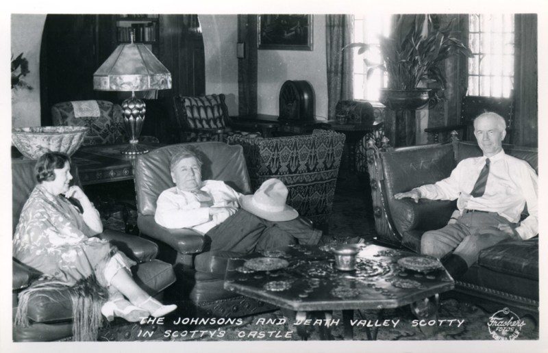
Named after Walter Scott AKA “Death Valley Scotty”, Scottys Castle or the Death Valley Ranch is located on some 1500 acres in Grapevine Canyon in Death Valley.

Built by Scott’s benefactor Albert Johnson in 1922, the Death Valley ranch cost between 1.5 – 2.5 million to construct at that time.  The stock market crash of 1929 cost Johnson a considerable amount of money, and the ranch was never finished.

Scotty was a prospector, stunt rider and con man who used to con investors in to backing his “mining” adventures.  It was reported that when the investor’s delegation wanted the view their new mine, Scotty would march them around the hot valley until they forgave or forgot about their investment.

Death Valley Scotty and the Johnsons

On March 11, 1906 Scotty stared as himself in a play which opened in Seattle to a full house.   We was arrested after his only performance and the charged for his crimes, the publicity exposed him to new investors.  In spite of this Albert Johnson maintain interested in his “mine”. Another investigator was sent, who reported back that the mine did not exist. Johnson refused to believe this, and the following year he visited the mine himself, but left without seeing the mine.  He was later sued by his investors in 1915 and ended up in jail.

A welcoming view when travelling the hot distances of Death Valley.

In 1922, Johnson started building Scotty’s castle as a vacation home.  When the size and scope of the property was realized, people assumed Scotty used the proceeds for his gold mine to pay for the Ranch.  Scotty, ever the promoter did nothing to correct the record and soon The Johnson’ vacation home is associated with him

The Death Valley Ranch was know as “Scotty’s Castle  in spite of the fact that Scotty rarely stayed over, rather living and sleeping at a 5 room cabin in lower vine canyon a short distance away

A unique perspective of the Death Valley Ranch.

Due to its remote location, the Death Valley Ranch needed to maintain its own power station and water supply and evaporation cooling system. Despite the conditions, Scotty’s Castle boasts a 1,121 pipe theater organ, fountains, clock tower and a massive unfinished swimming pool.

Water "Death Valley Scotty" Scott's grave overlooks the Death Valley Ranch
Water “Death Valley Scotty” Scott’s grave overlooks the Death Valley Ranch

There is no longer gas available at Scotty’s castle or grapevine canyon.

Scottys Castle was flooded in 2015 and not currently open to the public. The opening date has been pushed many times and currently scheduled for 2022. The flood was the result of over 3 inches in rain in just over 5 hours. The flash flood left debris in the visitors center over one foot deep and washed out the road.

Scotty’s Castle Summary

NameScotty’s Castle
LocationDeath Valley National Park, California
National Register of Historic Places78000297

Further Reading

Scotty’s Castle Map

Scotty’s Castle Personalities

Leadfield California – A Death Valley Ghost Town

Leadfield California is a ghost town located in Inyo County and Death Valley National Park and found on the Titus Canyon Trail. The town boom in 1925 and 1926, however, Leadfield is a town that was started on fraud and deceit.

Leadfield Gost Town, Death Valley, California

According to Legend and an article in Desert Magazine, and shameless promoter C. C. Julian wandered into Titus Canyon and started blasting tunnels. He then discovered lead ore which he purchased and brought down from Tonopah, Nevada. Julian then produced maps and other promotional materials and found investors from the East coast. The town of Leadfield was born and died on the imagination of this one man.

Photograph of an exterior view of the Leadfield Hotel in Death Valley's Titus Canyon, [s.d.]. The hotel is a simple wooden structure with a slanted roof and a rectangular façade. The upper left corner of the façade is missing, revealing the interior of the building. Three large rectangular windows and two doors alternate across the front of the building. There are three people standing on a caved-in porch in front of the hotel. A large rocky mountain rises up behind the hotel. The hotel was part of C. C. Julian's Leadfield boomtown, the hey day of which was in 1925. Photo Credit “University of Southern California. Libraries” and “California Historical Society” as the source. Digitally reproduced by the USC Digital Library.
Photograph of an exterior view of the Leadfield Hotel in Death Valley’s Titus Canyon, [s.d.]. The hotel is a simple wooden structure with a slanted roof and a rectangular façade. The upper left corner of the façade is missing, revealing the interior of the building. Three large rectangular windows and two doors alternate across the front of the building. There are three people standing on a caved-in porch in front of the hotel. A large rocky mountain rises up behind the hotel. The hotel was part of C. C. Julian’s Leadfield boomtown, the hey day of which was in 1925. Photo Credit “University of Southern California. Libraries” and “California Historical Society” as the source. Digitally reproduced by the USC Digital Library.

The truth of the tale is not quite as interesting or spectacular. According the the National Park Service, Leadfield ore was first worked in 1905. During the Bullfrog boom, which took place outside of Beatty, prospectors worked the land looking for the next big hit. In the fall of 1905, nine mine sights were identified and claimed by W. H. Seaman and Curtis Durnford. The ore from these sites was assayed in Rhyolite at $40 per ton. The men bought out a local consortium and the Death Valley Consolidated Mining Company was incorporated which released promotional material and sold shares for 2.5 cents each.

The mine and its ore did produce, however the Death Valley Consolidated Mining Company soon discovered that the expense of hauling the ore to Rhyolite and then the frieght costs to ship the material to smelters further off caused the ore to be not profitable. After six months of operation the Death Valley Colisidated Mining Company disappeared.

C. C. Julian
C. C. Julian

Despite early failures, in March of 1924 three prospectors wandered into the canyon and staked several claims. Ben Chambers, L. Christensen and Frank Metts worked their claims of lead ore for over one year before selling the claims to John Salsberry. Mr. Salsberry saw enough promise to form the Western Lead Mines Company and started to raise capital via stock sales at $0.10 per share. By the end of 1925, the Western Lead Mines Company was working 50 claims in the valley and soon began in invest in infastructure in the form of a compressor plant. A long steep road was constructed for LeadField to the Beatty Highway.

In early 1926, the Western Lead Mines Company build a boarding house and piped in water from a nearby spring. The town of Leadfield was named officially January 30th, 1926. Stock from the Western Lead Mines Company went on sale in January and within a 24 hour period, 40,000 share of stock were sold at $1.57 per share.

In February 1926 it became known to the public that C. C. Julian purchase shares and was now President of Western Lead Mines Company. Almost immediately the California State Corporation Commission began an investigation into the stock sale because a permit was not granted for the stock sale. The promoter went to work, along with several other mine operations, raise interest and money for the town. City plans were filed with Inyo County, however the spectre of investigation loomed.

Julian at the Western Lead Mine located in Leadfield, California - Photo Los Angeles Times
Julian at the Western Lead Mine located in Leadfield, California – Photo Los Angeles Times

Despite the arrival of a post office, investment into the location, and hundreds of feet of tunnel, C. C. Julian was ordered to cease sale of stock by the California State Corporation Commission. Around the same time, the primary tunnel of the Western Lead Mines Company penetrated to the ledge which experts predicted the highest quality ore. This ore was assayed at 2% and far too low for profit considered freight costs.

"The Last Days of C. C. Julian," Los Angeles Times, 29 Sept. 1935
“The Last Days of C. C. Julian,” Los Angeles Times, 29 Sept. 1935

Leadfield and the surrounding mines where gone months later. Mr. Julian was blamed despite the facts that he did not start the venture, there was ore at the location, and he invested money and time towards the venture. Once his Leadfield venture faltered, he moved onto to Oklahoma and was caught up in yet another scam. Julian later fled the country for Shanghai in March of 1933 m where he committed suicide in 1923 after several more failed schemes. Julian was buried in a beggers coffin and his funeral was attended by nine people.

Mr. Julian is responsible for the road through Titus Canyon, which many is a favorite route of visitors every year.

Leadfield Sign, Death Valley, California

For a detailed history, the NPS offers a great article.

Leadfield Town Summary

NameLeadfield
LocationInyo County, Death Valley, California
Latitude, Longitude36.8466107,-117.0592307
GNIS1658952
Elevation4000 feet
Newspaper Leadfield Chronicle ( 192?-19?? )
National Register of Historic Places75000221

Further Reading

Leadfield Map

Resources

Owens Lake Steamships

Today it is difficult to imagine, but at one time not so long ago, Owens Lake Steamships ferried supplies and silver ore across Owens Lake from the booming silver town of Cerro Gordo, California. Cerro Gordo was a booming silver town located at high elevations in the White Mountains above the tree line. Water and fuel are hauled up the mountain utilizing freight wagons to support the silver mines.

Cerro Gordo overlooking the then full Owens Lake.

Owens Lake, nestled in the Owens Valley of California, was once a shimmering gem nestled beneath the towering Sierra Nevada mountains. Spanning over 100 square miles, it was a vital oasis for diverse wildlife and a haven for migratory birds. Its glassy surface reflected the surrounding peaks, creating a picturesque landscape beloved by locals and travelers alike. With its abundant water and fertile shores, it supported Native American communities for centuries. However, as Los Angeles began to grow in the late 19th century, demands for water led to the diversion of the Owens River, gradually desiccating Owens Lake and leaving behind a vast salt flat.

Mortimer Belshaw (1830 - 1899 )
Mortimer Belshaw (1830 – 1899 )

Cerro Gordo was a silver mining town located high in the White Mountains east of Owens Lake. The elevation of the town offered some unique challenges in terms of supplies, such as water and fuel. Infrastructure to support the mines and the community needed to be built by Mortimer Belshaw. These supplies are staged in Keeler, CA and hauled up to the town using teams of wagons and a tramway. It is a natural step to build a ferry system to facilitate the transfer of goods, services and more importantly silver bars produce at Cerro Gordo.

Owens Lake itself faced a significant transformation in the 20th century. The Los Angeles Aqueduct, completed in 1913, diverted water from the Owens River, which fed the lake, to Los Angeles. This diversion caused Owens Lake to dry up, transforming it into a largely dry lakebed with environmental and health issues due to dust storms.

Bessie Brady

1950 Painting by William McKeever of the Bessie Brady is on display at the Eastern California Museum in Independence, CA.  This image probably does not resemble the actual appearance of the vessel.
1950 Painting by William McKeever of the Bessie Brady is on display at the Eastern California Museum in Independence, CA. This image probably does not resemble the actual appearance of the vessel.

The Bessie Brady made its maiden voyage on July 4, 1872. Measuring about 85 feet in length with a 19-foot beam, the vessel could carry up to 100 tons of cargo, significantly reducing the time and cost of transporting ore. The ship’s route ran from the town of Swansea, near the western shore of Owens Lake, to Cartago on the southern shore. From Cartago, the ore was transported to Los Angeles. The steamer was actually so efficient in hauling silver ore to Cartago Landing, near Olancha, Ca, that the bullion began to pile up. The teamsters who hauled the Silver Ore from Olancha to Los Angeles, simply could not keep up with the vessel.

The introduction of the Bessie Brady revolutionized transportation in the Owens Valley. It provided a more reliable and faster means of moving ore from the Cerro Gordo Mines to markets, boosting the local economy. The steamship also transported supplies and passengers, further integrating the remote mining community with the rest of California.

The success of the Bessie Brady was relatively short-lived. By the mid-1870s, the completion of the Carson and Colorado Railroad reduced the need for lake transport. The railroad provided an even more efficient means of moving goods and people, leading to a decline in the use of the steamship.

Despite its decline, the Bessie Brady continued to operate for several years, serving various purposes, including transporting salt from the lake’s evaporative salt works.

NameBessie Brady
Other Names“The Pioneer inland steamer of the Pacific Coast”
Years of OperationJune 27, 1872 – May 11, 1882
Length85 feet
Beam16 feet
Propulsion20 HP Single Cylinder Oscillating Type Steam
10 inch cylinder bore and 10 inch stroke
Propeller54 inches

Molly Stevens

The Molly Stevens was a steamboat built in the late in 1877 and launched on in May of that year by Colonel Sherman Vanderventer Stevens. It was named after Molly Stevens, in honor of his daughter Molly.. The vessel was is smaller than the Bessie Perl, but does boast of more powerful powerplant. A few days after its’ maiden voyage, the steamship is swamped in the heavy wind driven lake waters. She is raised again to the surface with the help of the Bessie Brady.

By 1878, the Molly Stevens is only making the occasional trip across the Lake and spends the majority of her time moored. In 1881, the vessels is hauling from $6,000 in bullion a week, which is produced by nearby mills. Due to lack of hauling efficiency, the Molly Stevens is again moored and eventually scrapped in the spring of 1882.

On May 11th, 1882, during a refitted of the more powerful steam plant from the Molly Stevens to the Bessie Brady a fire breaks. The fire is started spontaneously by a combination of the Oakum, oil, paint and tar. The inferno quickly takes hold and destroys the last of the steamships on Owens Lake.

The Molly Stevens and Bessie Brady played a crucial role in the economic development of the Owens Valley. By transporting ore efficiently across Owens Lake, these vessels helped boost the mining industry, which was the backbone of the local economy. The presence of the two steamships reduced the time and cost associated with overland transport, making mining operations more profitable.

Molly Stevens Characteristics

NameMolly Stevens
Years of operation1877 – 1882

The Lost Treasure of the Bessie Brady

One other incident, which is not documented, is the alleged existence of a lost treasure in Owens Lake. Allegedly, a wagon load of bullion hauled by the Bessie Brady is swept overboard during a high wind storm. The tale is told that the heavy bullion-filled wagon was not correctly chained to the deck and simply swept over the side.

The story could be from a combination of events, such as the swamping and sinking of the Molly Stevens.

Seemingly a rumor, the Lost Treasure of the Bessie Brady seems to always originate from a person who allegedly heard from someone who knew the captain.

References