Friday’s Station – Pony Express

Friday’s Station is Union Army Military Post and Pony Express Station located near Lake Tahoe, in Douglas County, Nevada. The two story building is originally built as an inn and pony express station in 1860. The station is designated as a home station, where extra horses, firearms, men and provision are kept.

Friday's Station was a Pony Express station at Lake Tahoe - (Nevada Historical Society
Friday’s Station was a Pony Express station at Lake Tahoe – (Nevada Historical Society

Originally, the buildings are intended for the Union Army in the District of California. The location is chosen for the pony express due to its proximety to Lake Tahoe and the state line. Becuase of its location, the station is refered to as the “Lakeside Station” by some. In April, 1860, Robert (Pony Bob) Haslam made the first ride and shipment of mail from Sacramento at Friday’s Station and made his first run to Buckland’s Station, a distance of seventy five miles to the east.

Friday's Station with five freight teams and a prairie schooner arriving.
Friday’s Station with five freight teams and a prairie schooner arriving.

After the pony express failed, the property operated as a resort known as the “Buttermilk Bonanza Ranch.” Today, the original buildings still state and recognized as California Historical Landmark #728 and is listed on the National Register of Historic Places.

Location Map

Location Summary

NameFriday’s Station
LocationDouglas County, Nevada
Other NamesLakeside Station
Park Cattle Company Residence
Buttermilk Bonanza Ranch
Latitude, Longitude38.9639,  -119.9347
Elevation6,324 feet
California Historical Landmark728
National Register of Historic Places86003259
NPS Station Number166
Next Westbound Station
Next Eastbound StationVan Sickle’s Station

References

Ragtown Nevada

Ragtown Nevada is ghost town and Nevada State Historical Marker number nineteen. The town and Nevada State Historic Marker are located in the Churchill County, Nevada. The town was located about eight miles west of Fallon Nevada. Originally, the town was located near Leeteville, but later is relocated to its historic location. Today, nothing remains of the old settlement.

Ragtown Nevada
Ragtown, Nevada

The site which will become Ragtown started in 1854 as a station along the Humboldt Overland Trail. The station is located on a small ranch and the site is the first watering hole for travelers west of the dry alkali Forty Mile desert. The Forty Mile desert is one of the most notorious sections of the transit and the site of many tragedies. Travelers would rest and recoup from the journey along the northern bank of the Carson River before starting for the Sierra Nevada. The name Ragtown comes from the clothing hung to dry from the women doing their laundry.

During the late 1850’s, small structures are built from willow poles and canvas as temporary shelters for travelers. A summer seasonal population is comprised of traders, gamblers and those of less notable reputation. Samuel Clemmons visited Ragtown in 1861 on his way out west.

A flood in 1862 destroyed all of the structures and disinterred some 200 graves. The site is temporarily abandoned until the Reese River Excitement in 1863 started a renewal. By the late 1860s a post office is established and the small population of farmers worked the area. The location is bypassed with the establishment of the Central Pacific rail service.

Today, nothing remains of Ragtown beyond a historic maker.

Nevada State Historic Marker Text

Ragtown was never a town. Instead, it was the name of a most welcome oasis and gathering point. This mecca on the banks of nearby Carson River received its name from the appearance of pioneer laundry spread on every handy bush around.

The Forty Mile Desert, immediately to the north, was the most dreaded portion of the California Emigrant Trail. Ragtown was the first water stop after the desert. To the thirst- crazed emigrants and their animals, no sight was more welcome than the trees lining the Carson River.

Accounts tell of the moment when the animals first picked up the scent of water—the lifted head, the quickened pace, and finally the mad, frenzied dash to the water’s edge. Then, emigrants rested for the arduous crossing of the Sierra Nevada that lay ahead.

In 1854, Asa Kenyon located a trading post near Ragtown, offering goods and supplies to travelers during the 1850s and 1860s. Ragtown was one of the most important sites on the Carson branch of the California trail.

HISTORICAL MARKER No. 19
STATE HISTORIC PRESERVATION OFFICEC
HURCHILL COUNTY MUSEUM COMMITTEE

Nevada State Historical Markers identify significant places of interest in Nevada’s history. The Nevada State Legislature started the program in 1967 to bring the state’s heritage to the public’s attention with on-site markers. Budget cuts to the program caused the program to become dormant in 2009. Many of the markers are lost of damaged.

Historic Photos

Desert Lake, near Ragtown, Western Nevada, ca. 1867 by Timothy H. O'Sullivan
Desert Lake, near Ragtown, Western Nevada, ca. 1867 by Timothy H. O’Sullivan

Pony Express

Townley identifies Ragtown as a station between Old River and Desert Wells. Like other stations on the “Stillwater Dogleg,” Ragtown probably functioned briefly as a Pony Express station in the summer and fall of 1861 and as an Overland Mail Company stage stop from 1861 to 1868. L. Kenyon and his family managed station operations at the site for nearly fifty years. The station’s name supposedly came from the common site of freshly washed travelers’ clothing spread out to dry on surrounding bushes.

Ragtown Summary

NameRagtown, Nevada
LocationChurchill County, Nevada
GNIS
PopulationTransitory, Seasonal, 50
Post Office186X –
Elevation4,029 feet
Nevada State Historic Marker19
Latitude, Longitude39.5057,-118.9215
NPS Pony Express Station160
Next Westbound StationDesert Wells Station
Next Eastbound StationNevada Station

Nevada State Historic Marker Map

References

Fort Churchill Nevada

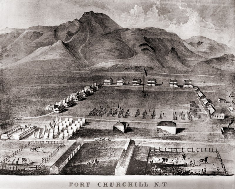
Fort Churchill is a Civil War era United States Army Fort, Pony Express Station and overland stage stop located in Lyon County, Nevada just West of Buckland’s Station. The station is designated as a home station, where extra horses, firearms, men and provision are kept. The fort was commissioned to protect early settlers from the east from Indian attacks. The garrison was the largest, most elaborate fortification in the Nevada Territory at the time.

A lithograph drawing of Fort Chuchill, Nevada Territory created by Grafton Tyler Brown in 1862

The discovery of gold in California caused a massive rush of people across the United States. Some of these early settlers came into the Nevada Territory and setup stage stops and mining operations. The arrival of settlers in their territory threatened the the Northern Paiute people. The increase populations of settlers increased the competition for local resources, such as game. These tensions, along with kidnapping and of rape of two young Paiute girls by prospectors from Williams Station erupted into Pyramid Lake War in 1860.

The U.S. Army fort was build along the Carson River and construction of Fort Churchill started on July 20, 1860. The base was named in honor of Sylvester Churchill who was the Inspector General of the Army. The fort is completed in early 1861 and home to some 200 soldiers charged with protecting settlers and mail routes. The post is abandoned in 1869.

On October 6, 1932, Nevada took control of the 200 acre fort and took steps to preserve the ruins as a state park.

Pony Express

Sources generally agree on the identity of Fort Churchill as a Pony Express stop. Built during the summer of 1860 by Captain Joseph Stewart and his men, the adobe fort housed the Pony Express station in its headquarters building. Construction on the fort began on July 20, 1860, approximately twenty-five miles from Comstock, Nevada, along the edge of the Carson River. When Richard Burton arrived at Fort Churchill on October 19, 1860, he gave it a positive review in his journal and named Captain F.F. Flint as the commander.

Since the Pony Express used Buckland’s as a home station, Fort Churchill probably assumed a similar function when the Pony Express transferred its station from Buckland’s to the fort. The Fort Churchill’s ruins existed as late as 1979, including the headquarters building, and it is a Nevada state park. 

Fort Churchill Map

NameFort Churchill
LocationChurchill County, Nevada
Other NamesFort Churchill Station
NPS Pony Express Station153
Next Westbound StationFairview Station
Next Eastbound StationBuckland’s Station
National Historic Landmark66000456

References

Buckland’s Station

Buckland Station is a pony express station, stage stop, boarding house and supplier near Fort Churchill in Lyon County, Nevada. The station is designated as a home station, where extra horses, firearms, men and provision are kept.

Buckland Station early 1900s

In 1857, Samual Buckland moved from California to the future site of Buckland’s Station. Buckland, a cattle rancher, improved the property by building a tradingpost, tent hotel, stage stop and toll bridge over the Carson River. A small log cabin was constructed in 1860.

Buckland’s Station served as a stop for the pony express when Buckland contracted with Bolivar Roberts in March 1860 for his ranch to serve as a Pony Express home station. Fort Churchill was established two miles to the west during the summer of 1860 as a result of the Pyramid Lake Indian War. With the establishment of Fort Churchill and its protective bulwarks, the pony express station was relocated.

On October 19, 1860, when Richard Burton visited Buckland’s, he described the station, as usual, in negative terms.

nps.gov

In 1861, Bucklands Station was honored as the county seat of Churchill County. It also served as the county seat for Lyon County Fort Churchill closed in 1869 and Samuel Buckland bought some of its building material and built a large impressive wooded framed house.

Buckland died on December 28, 1884 at 58 years in age. He and his family are buried at the Fort Churchill Cemetery. Today, the large house built by Buckland is restored and

Buckland Station Location Summary

NameBuckland’s Station
LocationLyon County, Nevada
Latitude, Longitude39.2946400, -119.2515470
GNIS856483
Elevation5000 feet
AliasBarnett, Barrett, Buckland Ranch, Bucklands, Tolles, Tolles Station, Weeks
Pony Express Stop No152

Buckland’s Station Trail Map

References

Diamond Springs Station

Diamond Springs Station is a Pony Express Station number 133 and located in a meadow in Eureka County, Nevada. Today the station is on private land which is believed to be owned by Olive Thompson. The station was described by Sir Richard Burton as the Eden of the Pony Express Trail when he visited the site on October 9th, 1860. He also reported that the site was managed by an unfriendly Mormon couple.

Diamond Springs Station
Continue Reading →