Lucy Grey Goldmine

The Lucy Grey Goldmine trail is a short 4×4 trip out of Primm, Nevada up to an old mine site.  The route is fairly accessible and almost any SUV or 4×4, but the route finding can be tricky is you are not careful.  A slight mistake in navigation and you will be in some rough country.  To find the trail head, exit and head past the outlet stores and the Lotto Store. The trail head is the dirt road where the paved road turns left.

Lucy Grey gold mine - An old truck marks the trail up to the mine. Built rigs might be able to make it, but I choose to hike. Photo by James L Rathbun
Lucy Grey gold mine – An old truck marks the trail up to the mine. Built rigs might be able to make it, but I choose to hike. Photo by James L Rathbun

The trail heads straight out into the desert. When you reach the railroad tracks, turn right and follow the road next to tracks until you reach a railroad signal station. There is a pass through under the train track and a nice little sign which reads Lucy Grey to let you know you are on your way.

From the railroad signal station the trail heads up an alluvial fan into the hills. Once you reach the gully and head into the hills, the trail becomes hard to follow, so pay attention to GPS coordinates, or your map. The trek is mostly easy with one or two small sections that will require you to pay a little more attention. The most difficult part of this trail is the route finding up to the mine and town site.

Continue Reading →

St Thomas Nevada – Clark County Ghost Town

Founded in 1865 when Brigham Young sent settles to the confluence of the Virgin River and Muddy Rivers.  St Thomas Nevada remained a Mormon settlement until 1871 when a surveying correction placed the town in Nevada.   When the Mormons abandoned the area, other settlers claimed the property.  St Thomas used to served as a pit stop for travelers between Los Angeles, California and Salt Lake City, Utah using along the old Arrow Highway (US 91).

St Thomas Ghost Town is accessible with lower water levels in Lake Mead, Lake Mead National Recreation Area, Nevada

The United States Federal Government “purchased” the land as part of the Hoover Dam project.  In actuality, there were multiple suits as the residents of St. Thomas raise complaints about the amount the federal government was paying for their land.  In time, the residence lost and the entire town was doomed to its destiny and the water of Lake Mead continued to rise.

St Thomas Trail head

The last known resident as Hugh Lord, who remained until the water surrounded his home.  He loaded is possessions into a row boat, set fire to his home, and rowed off into history.  Soon the rising water of Lake Mead swallowed the entire down, and wasted the landscape with water 60 feet deep.  From time to time, the lake level will drop low enough to expose this lost town.

The town is currently exposed, and lies in the lake bed surrounded by a large expanse of tamarisk.  The dirt road to the trail-head is located just inside the entrance to Lake Mead National Recreation Area when coming from Moapa and Overton and the trail is beyond simple and suitable for almost every vehicle.

Fresh Water Clam shells litter the area

The 2.5 miles hiking trail is very easy and takes you from the trail-head and loops through the town.  The trail would be a bit more difficult if you attempt the trail during the hot summer months.  Remains of the town are limited to foundations, some old wood fence posts and some metal artifacts such as farming equipment and a V-8 small block.  The park service appears to cut the tamarisk back to expose the foundations for visitors, however the cut off tamarisk trucks can be a tripping hazard and would be harsh it you fell on one, so keep in eye on where you step.

A building foundation in St. Thomas, Nevada
A building foundation in St. Thomas

I have been to many ghost towns over the years.  Many of them lost in history due to mines failing to produce, fire, hard environments and disease.  St Thomas is different from all the others.  This is a ghost town by design, by protest and there is no better reminder than the fresh water clam shells which litter the site.  The fact that there are viable towns (Moapa and Overton) just a few miles away make St Thomas all the more poignant.

The tallest building remains of St. Thomas,
The tallest building remains of St. Thomas

St Thomas Trail Map

Aurora Nevada – Mineral County Ghost Town

Aurora, Nevada is a ghost town in Mineral County about twenty eight miles southwest of Hawthorne, near the California border. Aurora is often mentioned as a footnote to larger better preserved town on Bodie, CA located just a few miles away.  Like most unprotected ghost towns today the town site is a just a remnant of its past, having lost much through heavy damage from vandals over the years.

The road leading into Aurora was once a 4×4 road and difficult to make it back into Aurora. Often the winter snows and spring rains rutted out the road leading to the town.

Aurora, CA photograph from the 1930's
Aurora, CA photograph from the 1930’s

Aurora was founded in 1860 by J.M Corey, James N Braley, and E.R Hicks while prospecting south west towards Mono Lake.  The “Eureka” moment came when gold and silver quartz was found while searching for water and game. Soon the word was out, and a migration of miners came up from Monoville and several other California towns.  Like many boom towns, Auroras population reach about 1,400 by 1861 and just one year later was almost 6,000.  Aurora boaster an 8 position stamp mill and the ore was hauled from the town via Wells, Fargo and Company. The town was constructed mainly from brick, as wood is a scare and finite resource in the area.

Aurora, Nevada as it existed in the 1800s

The Esmeralda Star was the town paper when the town reach is maximum population of 10,000. Life is town was rough and conditions were very harsh.   The territories of both California and Nevada tried to lay claim to the newly prized Aurora and in the spring of 1861, Mono County was founded by California, which fixed the seat of the county in the little town of Aurora.  Not to be outdown, in November of 1861, Nevada setup the head quarters of Esmeralda County in Aurora.  This dual county seat arrangement lasted for two years during which time both California and Nevada maintained two different county and exercised jurisdiction concurrently.

Aurora after 1910, when the town was first connected to electrical power.

To settle the issue, Nevada and California jointly commissioned a survey to finally settle the issue and established the location of the border.  During the elections held in September 1863 Aurora had the distinction of voting in two elections.  The Mono County voting was held in the police station and voters could walk over to Armory Hall to vote in the Esmeralda county elections for Nevada.  Three weeks after the election, the survey results came in and Aurora was officially 4 miles inside the state of Nevada.  The Mono County Officials loaded up their records and assets into Wagons and moved the seat to Bodie, CA some 10 miles to the south west.

Samuel Langhorne Clemens September 1-2, 1867, Pera, Constantinople

1862 found a young Samuel Clemens (Mark Twain) in town for several months looking the make his fortune.  During his stay he worked as a laborer in the stamp mill for $10 a week including board.  The young Mr. Clemens quickly gave up mining and sent several lively sketches to the Territorial Enterprise located in Virginia City.  Several weeks later Samual Clemens was hired by the Enterprise where he adopted his pen name, and Mark Twain was born.

Today there is not much standing at Aurora

In 1863 Aurora is pictured as a cluster of huts made of stone, sheltered by canvas or tin roofs, with streets of wooden buildings , and many substantial brick structures near the center of town, and uncountable tents and dugouts in the surrounding hils. About 5,000 persons lived in these makeshift shelters and in the 700 houses, and enjoyed the services provided by the hotels , churches, 20 stores, 22 saloons and 16 quartz mills .

National Register of Historic Places Inventory – Nomination Form – July 30, 1974

As with many gold towns, Aurora life was bright and short. Shallow mines could not support the town of 22 saloons and 20 stores and mismanagement and poor investments doomed the small town.  There was virtually no family life in the town. Prostitutes made up over 50% of the female population and by 1870 the gold and silver was gone, and the town soon faltered officially closing the post office in 1897.

A resurgence of Aurora started in 1906 when mining resumed in the area.  A post office was again opened to serve several hundred people, and a weekly called the Aurora Borealis was the paper of record.  During the revitalization of Aurora, the Aurora Consolidated Mining Co. claimed 1.8 million dollars in gold during World War I.  However, in 1919 the post office closed again and the town faded into history.  After World War II much of the brick town was demolished to satisfy the demand for the used brick market in 1946.

Remains of Aurora bricks found deep in the undergrowth.

The site of Aurora is all but gone and consisting of little more than a cross roads, a cemetery and a few foundations.

Aurora Town Summary

NameAurora
LocationMineral County, Nevada
Latitude, Longitude38.2871421, -118.9006963
GNIS858760
Elevation7400 feet
Post Office – 1919
NewpapersEsmeralda Star May 17, July 5, Sept 20, 1862; Nov 18, Dec 30, 1863
Aurora Daily Times Nov 27, 28, 30, Dec 1, 9, 11, 12, 1863; July 11, Oct 7, 1864
Esmeralda Daily Union Mar 23, 1864 – Mar 15, 1865; Nov 27, 1867 – Oct 3, 1868
Esmeralda Herald Oct 20, 1877 – July 29, 1882; Aug 18, 1883 – Apr 19, 1884
Aurora Borealis Dec 3, 1905

Aurora Trail Map

Aurora Personalities

Samuel Langhorne Clemens September 1-2, 1867, Pera, Constantinople

Samuel Langhorne Clemens – “Mark Twain”

Before he wrote American classic novels as Mark Twain, Samuel Langhorne Clemens was a miner and newpaper reporter in Mineral County, Nevada. Prior to picking…

Further Reading

Aurora, Nevada 1860-1960: Mining Camp, Frontier City, Ghost Town

This expanded Second Edition of Aurora, Nevada 1860-1960 chronicles the history of one of Nevada’s earliest and most important mining boomtowns. It is a reference-oriented…
Nevada Ghost Towns and Mining Camps - By Stanley W. Paher

Nevada Ghost Towns and Mining Camps

Nevada Ghost Towns and Mining Camps - By Stanley W. Paher Nevada Ghost Towns and Mining Camps is a wonderful book written by Stanley W.…

Resources

Racetrack Valley

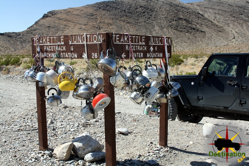
TeaKettle Junction lets you know you are starting to get close to the Racetrack.

Racetrack valley is a rough graded road which departs the Ubehebe Crater site and heads south into the desert. The road is rough, but easily passable in a regular car. However, when entering back country areas such as this it is always a good idea to have the insurance of a reliable vehicle, high clearance, four wheel drive, etc…  Do yourself a huge favor and air down your tires if you are properly equipped to air up when the trip is over.

Looking north from the Lippincott Mine towards the Racetrack off in the distance.

The racetrack valley road is a 25 miles one way trip to the playa. The road is grated, but can be heavily wash-boarded depending on the time of year, rain fall, etc…

Along the way, there are many side trips and alternate trails to help expand your visit.

As you leave Ubehebe Crater, you will be driving south and gradually gaining elevation. Take your time and enjoy the drive, if you are lucky you may see a big horn sheep herd. The road gradually gains in elevation and climbs through a Joshua Tree Forest.

Once you reach the pass, the road continues to drop in elevation all the way down to the playa. Continue straight through tea kettle junction, and bear left down the valley past the side road to the Lippincott mine, which is a great side trail.

The Racetrack Playa of Death Valley.

As you continue past the road to the Lippincott mine the road drops down to the Racetrack Playa itself. The first stop is ‘The Grandstand’ which is an outcropping of rock located in the north west corner of the racetrack. The second stop is the parking area to hike towards the stones. Don’t try to hike to the stones from the first Grandstand parking lot, or you will be hiking significantly further.

The highlight of the trip, is a short hike to the sailing or racing stones. The start of the hike is the parking area at the southern end of the racetrack playa.

Jeeps and Labradors are not allowed on the playa!

To reach the stones hike east from the parking lot across the playa towards the dark stone hillside. It is short FLAT, meaning really FLAT hike towards the stones. Be sure the check the temperatures before you leave, and bring lots of water. This is true with anything you might want to do in Death Valley. Don’t walk on the playa if it is wet or muddy.

The Racing stones.
The Racing stones.

At the end of the 30 miles road there is a small primitive campground for overnight visits. Be sure to check with the National Park Service for regulations of back country camping within the park.

Every racetrack needs a grandstand.

Notoriety

On September 19th, 1969 a Michigan front end loading is found burning along the road near the playa. Apparently, Manson order the machine burned. Park Rangers were deployed to the Racetrack. The rangers followed a set of tire tracked which belonged to a Toyota Land Cruiser which was stolen by Manson. The follow up investigate lead to the arrest of Charles Manson at Barker Ranch on October 12th, 1969.

Racetrack Valley Trail Map

References

Potosi Nevada – Clark County Ghost Town

Potosi Nevada is the oldest lode mine in Nevada and the town site is located just off highway 160 between Las Vegas and Pahrump, Nevada.  The site was started in 1856 by some Mormon prospectors who were lead to the location with the help of a Piute guide.  The Mormons found the site in April 1856 and a month latter it was named Potosi after the boyhood home of Nathaniel Jones.  They did not begin mining until August after a return trip to Utah for supplies.  

Potosi mine, south center of sec. 12, T. 23 S., R. 57 E., the mine workings explore a zone at the base of the Yellowpine limestone. Clark County, Nevada. Circa 1921. Plate 33-B in U.S. Geological Survey. Professional paper 162. 1931.

By September, the first wagon of ore sent back to Utah for trading and three months later three wagons returned with supplies including bellows, furnace, and hearths among other things.  On Christmas day 1856, an crude adobe furnace was used to smelt ore.

In the spring of 1861, a larger smelter was setup by the Colorado Mining Company at the Potosi Spring.  News of new silver mine spread all over the west in no time.  The town of Potosi was setup 700 feet below of the Potosi Mine or the Las Vegas Silver Mines as they were called and was soon home to 100 miners.

Carol Lombard was killed on a Douglas DC-3, Jan 16, 1942 on Mt Potosi

The site continued to slowly grow and develop until 1906.  In 1913 the Empire Zinc Company purchased the rights and was soon Potosi was Nevada’s largest producer of Zinc.  After nearly 100 years of production Potosi produced about 4.5 million in lead, silver and zinc.

Potosi is a designated at Nevada State Historic Marker no. 115.

Town Summary

NamePotosi
LocationClark County, Nevada
GNIS849366
Latitude, Longitude35.9708, -115.5408
Elevation5705
Population100

Potosi Trailmap

References