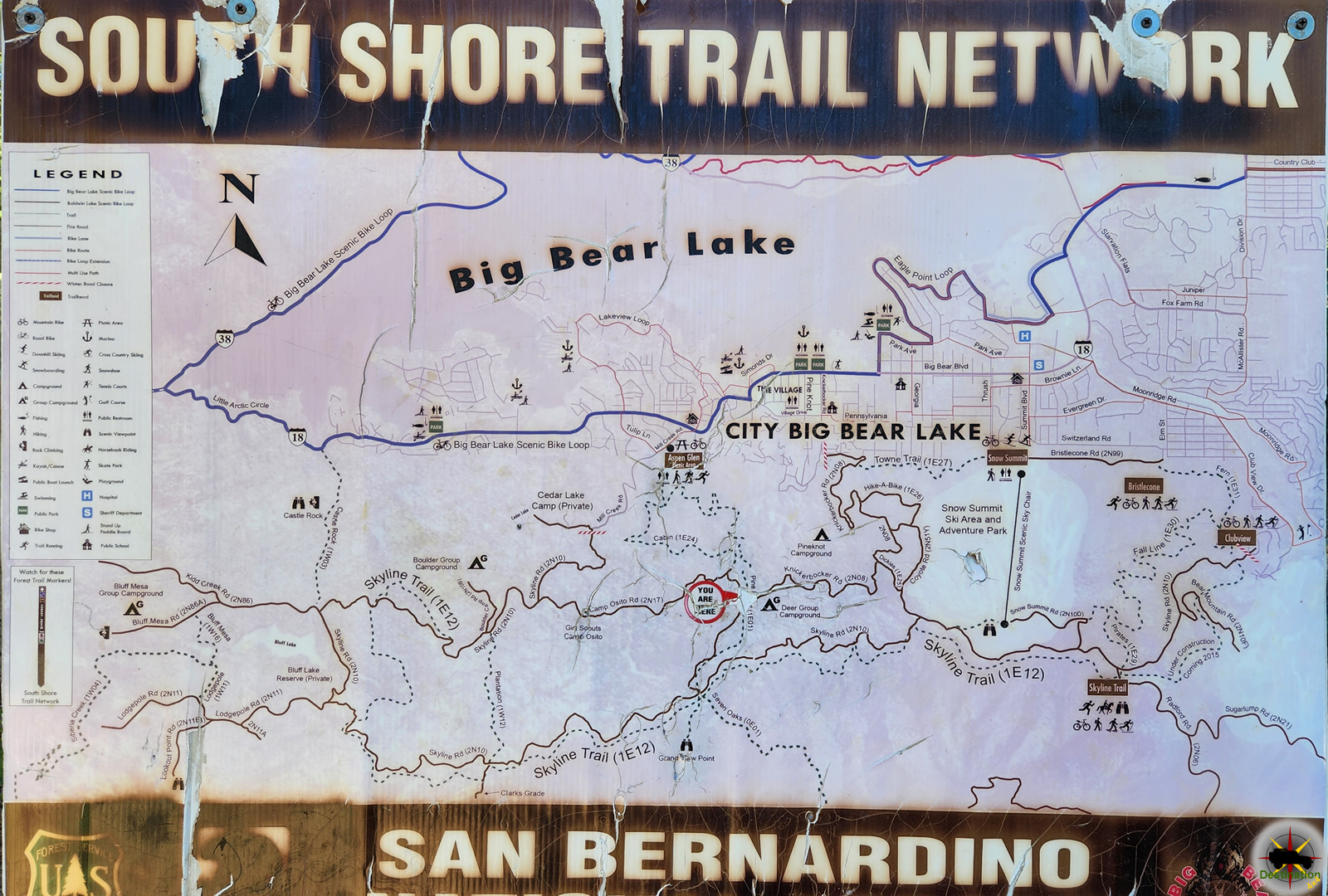
Holcomb Valley Road 3N14

Holcomb Valley Road 3N14 takes you through scenic Holcomb Valley

Holcomb Valley Road 3N14, is a main artery in the road system above and behind Big Bear and with Holcomb Valley in San Bernardino County. This is a very easy route offers access to many trails, campgrounds, hikes and points of interest, including Dishpan Springs in the West and the John Bull, Gold Mountain and Jacoby Canyon Trails in the East.

From the East, the trail is found off of Doble Road near the north end of Baldwin Lake. The trail quickly climbs up to the Holcomb mine and mill sites. From there a quick transverse across Gold Mountain where the 3N14 trail proceeds to run the length of Holcomb Valley.

Holcomb valley is named for William Francis “Grizzly Bill” Holcomb, who, in 1860 discovered gold in the area. The prospecting life can be tough, and this is not different in the valley which would be named for Grizzly bill. This discovery started a gold rush and soon the town of Belleville was founded. The town reached a size on 1500 people, boasted 50 murders and contained a “Hanging Tree” where the guilty met their justice.

A Forest Service Adventure Passes are required if you plan on stopping along the way. As of September 2016, forest visitors parked in standard amenity recreation fee sites in the four southern California national forests must display a valid recreation pass. This includes sites on the Angeles, Cleveland, Los Padres and San Bernardino National Forests. Such is the once great state of California.

Holcomb Valley Road Trail Map

Resources

Gold Mountain 3N69

Gold Mountain 3N69 Trail Head
Gold Mountain Trail Head

The Gold Mountain 3N69 Trail can be found in the San Bernardino National Forest near Big Bear Lake. The favored direction of travel is from South to North starting on Hwy 18 near Baldwin Lake. Starting immediately from the trail head, the trail climbs steeply up the mountain via a series of switch backs. Amazing views offer those who choose to drive this trail.

The trail is available to street legal vehicles only.

The US Forest Service rates the Gold Mountain 3N69 trail a black diamond most difficult trail. This trail is not recommended for stock SUVs. There are bypasses including one around the talus slope that will allow slightly modified vehicles to traverse the trail. Elevation ranges from 6700′ to over 8100′ and during the winter months snow and ice add to the difficulty of traversing the trail.

A Forest Service Adventure Passes are required if you plan on stopping along the way. As of September 2016, forest visitors parked in standard amenity recreation fee sites in the four southern California national forests must display a valid recreation pass. This includes sites on the Angeles, Cleveland, Los Padres and San Bernardino National Forests. Such is the once great state of California.

Gold Mountain Trailmap

Jacoby Canyon 3N61

Jacoby Canyon 3N61 Trail head

Jacoby Canyon 3N61 is a trail which can be found in the San Bernardino National Forest near Big Bear Lake. Jocoby Canyon was originally named Chipopee Canyon on U. S. Forest Service maps prior to 1965. The favored direction of travel is from North to South starting on Hwy 18. The bumpy dirt trail is available to street legal vehicles only but reasonably higher clearance is recommended.

The US Forest Service rates this trail a blue square more difficult trail. There is one creek crossing near the middle of the trail that will put a squeeze on full size vehicles.

Elevation ranges from 6000′ to over 7200′ and during the winter months snow and ice add to the difficulty of traversing the trail. This one way trail starts near the Holcomb mine and slowly winds down through a small narrow side canyon. The canyon offers some enjoyable scenery and in general the trail and route are quite fun.

Jacoby Canyon appears to have some smaller single space campsites near the bottom of the route. The trail releases onto Highway 18 near Cactus Flats. The short trail offers prime opportunity to see wildlife and to get away from it all in the back-roads of Big Bear.

A Forest Service Adventure Passes are required if you plan on stopping along the way. As of September 2016, forest visitors parked in standard amenity recreation fee sites in the four southern California national forests must display a valid recreation pass. This includes sites on the Angeles, Cleveland, Los Padres and San Bernardino National Forests. Such is the once great state of California.

Jacoby Canyon is currently closed following a wild fire by a forest order of the Forest Service.

Jacoby Canyon Trailmap

Resources

Alamo Road

Alamo Road and parts beyond
Alamo Road and parts beyond. Photo by James L Rathbun

The Alamo Road is the central route north through the Desert National Wildlife Refuge north of Las Vegas.  The Route leaves from Corn Creek and winds north over Sheep Pass and into the Pahranagat National Wildlife Refuge.  There are many spur trails to explore and several primitive campsites to spend the night.

This road travels just along the eastern boundary of the Nevada Test & Training Range.  Entry into this area is prohibited, so do not travel west from this trail. There are several other shorter trails which leaves Alamo trail toward the east to several side canyons.

The trail is very remote and covers a good distance. The last time we did this trail, cell service died rather quickly outside of Corn Creek. So, be prepared and pack appropriately. I have a CB and a 2M ham radio in the jeep for just such an occasion.

Alamo Road offers access to the following Las Vegas 4×4 Trails:

  • Joe May Road
  • Cow Creek Road
  • Hidden Forest Road
  • White Rock Road
  • Dead Horse Road
  • Sheep Pass
  • Cabin Spring Road

The Mormon Well Road also starts from Corn Creek.

Alamo Road Trail Map

Pine Nut Road

The turn off to Pine Nut Road off the Mormon Wells Road near Las Vegas, Nevada

Pine Nut Road is a 6-mile long, bumpy dirt road on the east side of the Sheep Range that runs north from the Mormon Well Road to a traditional primitive camping area. This camping area offers several campsites with one which overlooks the valley below and would be a nice place to cool down on a hot summer trail ride.

Pine Nut is just inside the Pinyon-Juniper Woodland zone, which means the campsites are shaded by Single-leaf Pinyon and Utah Juniper.

The road usually requires only a high-clearance vehicle, but it can get troublesome crossing the first large wash; call the refuge headquarters for current conditions.

A nice place to camp at the end of the trail.

The primitive campsite offers no services and although the area is under Junpiter Trees, firewood should be brought to the site for campfires. There are a few fire pits outlined with rock and offer nice small clearing to keep the fire hazard down. The campsites are separated from each other with Jupiter trees.

A flowering cactus blooms in the spring
A flowering Mojave Mound Cactus blooms in the spring, found on Pine Nut Road