Taylor, Nevada, located in White Pine County approximately 15 miles southeast of Ely, was a quintessential mining boomtown of the late 19th century. Established following the discovery of silver and gold in 1873, Taylor epitomized the rapid rise and fall of mining communities in the American West.

Founding and Early Development (1872–1880)
Silver and gold were discovered in 1873 by prospectors Taylor and John Platt, guided by a local Native American, Jim Ragsdale, who was paid $500 for leading them to a silver ledge. The Taylor Mine was staked and sold in 1875 to the Martin White Company of Ward for $14,000. Concurrently, the nearby Monitor Mine was discovered, laying the foundation for the town’s growth. However, significant development did not occur until 1880, when the camp of Taylor began to take shape. In 1881, the Monitor Mill and Mining Company constructed a ten-stamp mill seven miles northwest of Taylor on Steptoe Creek, which began operations in September 1881, processing ore from the surrounding mines.
Boom Period (1881–1886)
Taylor’s peak came in 1883, following new ore discoveries and the construction of the Argus Mill. The town’s population reportedly reached 1,500, though some historical markers exaggerate this figure at 15,000, likely an overstatement given the scale of operations. By the end of 1883, Taylor boasted a vibrant community with three general stores, four restaurants, three boarding houses, seven saloons, a brewery, a drugstore, a doctor’s office, a school, an opera house, a Wells Fargo office, and professional services. Two newspapers, the White Pine News and the Taylor Reflex (relocated from Ward), were published, reflecting the town’s cultural and economic vitality. The annual Fourth of July celebration became a social highlight, cementing Taylor’s role as a regional hub by 1886. During this period, the mines shipped over $260,000 worth of ore (approximately $8 million in 2025 dollars), primarily silver, with gold, copper, and lead as secondary outputs.
Decline (1885–1890)
Taylor’s prosperity was short-lived. By 1885, the free-milling silver ore began to deplete, and a tragic accident in 1886 at the Argus Mine—where a drill struck dynamite, killing one miner and blinding another—accelerated the town’s decline. The Monitor Mill closed in 1886, followed by the Argus Mill in 1889. By 1890, only a handful of residents remained, with many businesses and buildings relocated to nearby Ely, which was emerging as a more stable economic center.
Revivals and Final Decline (1918–1991)
Mining in Taylor saw intermittent revivals. In 1918, the Wyoming Mining & Milling Company built a 100-ton cyanide plant at the Argus Mine, processing 60,000 tons of ore in its first year (1919). The mill operated from 1921 to 1923, producing 40–50 tons of ore daily, but closed again due to falling silver prices. World War II temporarily spurred mining activity, with local mines yielding over $3 million in silver, gold, copper, and lead over their lifetime. In 1980, Silver King Mines, Inc., of Salt Lake City initiated a $10 million open-pit operation, which continued until 1991. This final phase destroyed much of what remained of Taylor’s original structures, leaving only a few buildings and mining remnants.
Present Day
Today, Taylor is a ghost town, with only two buildings remaining and much of the site obscured by modern mining operations. Located at coordinates 39°04’47.0″N, 114°41’07.0″W, it is accessible via a well-maintained gravel road off U.S. Highways 6, 50, and 93, near Ely. The Nevada State Historical Marker No. 99, erected by the Nevada State Park System and White Pine Public Museum, marks the site, summarizing its history. The area remains of interest for ongoing mineral exploration, but the town’s historical footprint is minimal, with most structures lost to time or modern mining.
Connection to Nevada Northern Railway
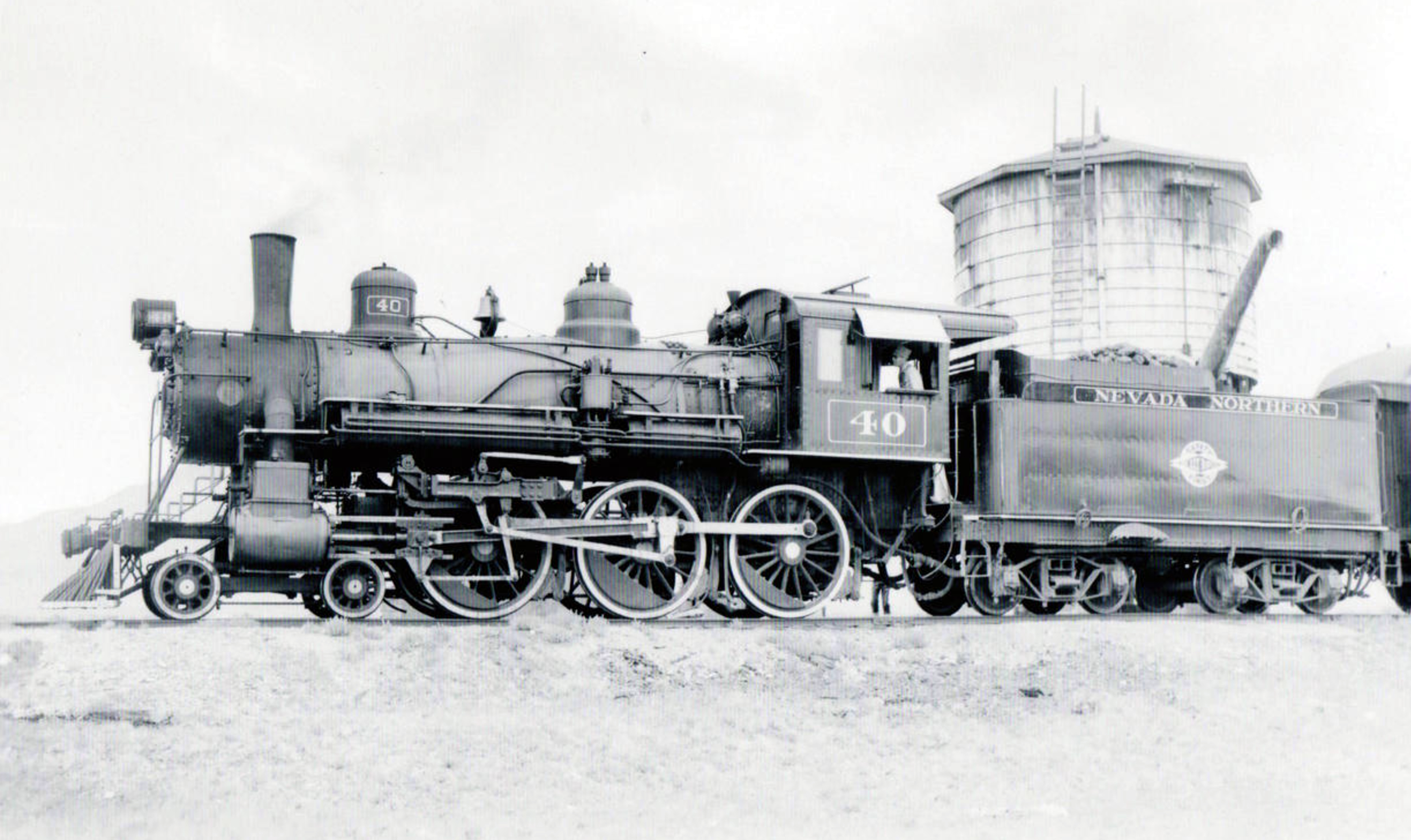
Taylor’s mining operations were closely tied to the Nevada Northern Railway, which connected Ely to national rail networks starting in 1906. While Taylor’s boom preceded the railway’s construction, the railway facilitated ore transport from nearby mines during later revivals, particularly in the early 20th century. The Nevada Northern’s Ore Line, extending to Ruth and McGill, supported the region’s mining economy, indirectly sustaining Taylor’s intermittent operations.
Conclusion
Taylor, Nevada, exemplifies the boom-and-bust cycle of Western mining towns. From its rapid growth in the 1880s to its near-total disappearance by the late 20th century, Taylor’s history reflects the challenges of sustaining resource-dependent communities. Its legacy endures through historical markers, sparse remnants, and its role in White Pine County’s mining heritage, preserved in part by the Nevada Northern Railway Museum’s efforts to document the region’s rail and mining history.
Nevada State Historic Marker
Nevada State Historical Markers identify significant places of interest in Nevada’s history. The Nevada State Legislature started the program in 1967 to bring the state’s heritage to the public’s attention with on-site markers. These roadside markers bring attention to the places, people, and events that make up Nevada’s heritage. They are as diverse as the counties they are located within and range from the typical mining boom and bust town to the largest and most accessible petroglyph sites in Northern Nevada Budget cuts to the program caused the program to become dormant in 2009. Many of the markers are lost or damaged.
Most of the markers across the state are large blue metal markers. However, there are a variety of other marker styles out there. For this guide they have been simplified into a few categories (blue, blue small, concrete, and stone). Sometimes, the markers are on buildings, fences, or metal stands.
Silver and gold were discovered by Taylor and John Platt in 1873 in what was to become Taylor, a typical mining community supported chiefly by the Argus and Monitor Mines. In seven years, the town boasted a population of 15,000 people, seven saloons, three general stores, an opera house, a Wells Fargo office, and other businesses. By 1886, Taylor was the center of county activity, a social highlight being the annual 4th of July celebration.
Mining continued intermittently until 1919. At that time, a 100 ton cyanide plant at the ArgusMine gave the area new life, but production declined when the price of silver plummeted. World War II renewed mining activity temporarily. Local mines yielded more than $3 million in silver, gold, copper, and lead.
STATE HISTORICAL MARKER NO. 99
STATE HISTORIC PRESERVATION OFFICE
WHITE PINE PUBLIC MUSEUM, INCORPORATED
Nevada State Historic Marker Map
Summary
| Name | Taylor, Nevada |
| Location | White Pine County, Nevada |
| Latitude, Longitude | 39.0885, -114.7522 |
| Nevada State Historic Marker | 99 |


